IMAGES TAKEN NEAR TO
Airyligg Drive, GLASGOW, G76 0LJ
Introduction
This page details the photographs taken nearby to Airyligg Drive, G76 0LJ by members of the Geograph project.
The Geograph project started in 2005 with the aim of publishing, organising and preserving representative images for every square kilometre of Great Britain, Ireland and the Isle of Man.

There are currently over 7.5m images from over14,400 individuals and you can help contribute to the project by visiting https://www.geograph.org.uk
Image Map
Images are licensed for reuse under creativecommons.org/licenses/by-sa/2.0
Notes
- Clicking on the map will re-center to the selected point.
- The higher the marker number, the further away the image location is from the centre of the postcode.
Image Listing (127 Images Found)
Images are licensed for reuse under creativecommons.org/licenses/by-sa/2.0
Image
Details
Distance
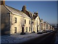
1
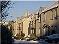
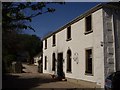
Polnoon Mews
Although a modern development, these houses in Polnoon Mews have features in a vernacular style such as wallhead dormers and sash-and-case windows. It is important to note that these aren't vernacular buildings which are by definition smaller traditional buildings which use local materials and building methods.
Image: © Kenneth Mallard
Taken: 3 Jan 2010
0.06 miles
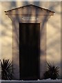
4
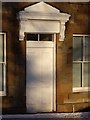
Doorpiece - Polnoon Street
Consoled and corniced doorpiece with plain panelled door with fanlight to an otherwise plain fronted two-storey house in Polnoon Street.
Image: © Kenneth Mallard
Taken: 3 Jan 2010
0.08 miles
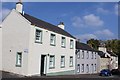
5
Polnoon Street
Looking down Polnoon Street towards Gilmour Street.
Image: © Kenneth Mallard
Taken: 3 Jan 2010
0.09 miles
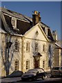
6
Mayfield House - doorpiece
Mayfield is plain fronted but has rusticated quoins and simple timber pilastered and pedimented doorpiece with plain panelled door.
Image: © Kenneth Mallard
Taken: 3 Jan 2010
0.09 miles
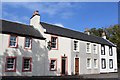
7
Vernacular building - Polnoon Street
This two-storey house in Polnoon Street was built in 1774 and tacked to James Tassie, merchant. The building comprises a number of different vernacular features such as a gambral roof; round-topped dormers; scrolled skewputs; three windowed projected elevation; pedimented nepus gable; rusticated quoins; pilastered doorpiece with overdoor and volute keyblocks above window openings. It has a five bay symmetrical façade. The farmhouse at Wester Kitochside Farm http://www.nts.org.uk/Property/41/ built in 1783 by Hendry Granger and Tom Lochore for John Reid has many similar vernacular features.
Image: © Kenneth Mallard
Taken: 3 Jan 2010
0.09 miles
8
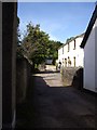
Coo Lane
Coo Lane leads off Polnoon Street http://www.geograph.org.uk/photo/1450275 near Mid Road. The lane originally led to the fields behind Polnoon Street. The building on the right (mid-photo) was once a United Presbyterian Church before the congregation moved to a new building in Montgomery Street. Click on these links to discover about the churches and Covenanters http://www.geograph.org.uk/photo/1424798 http://www.geograph.org.uk/photo/1897780 http://www.geograph.org.uk/photo/1432415 .
Image: © Kenneth Mallard
Taken: 12 Sep 2009
0.09 miles
9
Coo Lane
Coo Lane once led to the pastures behind Polnoon Street. The building in the foreground was once a United Presbyterian Church before the congregation moved to a new building in Montgomery Street. Click on these links to discover about the churches and Covenanters http://www.geograph.org.uk/photo/1424798 http://www.geograph.org.uk/photo/1897780 http://www.geograph.org.uk/photo/1432415 http://www.geograph.org.uk/photo/2385555 .
Image: © Kenneth Mallard
Taken: 30 Apr 2011
0.09 miles
10
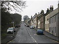
Polnoon Street, Eaglesham
Looking up Polnoon Street from Gilmour Street.
Image: © G Laird
Taken: 3 Jan 2013
0.09 miles