IMAGES TAKEN NEAR TO
Polnoon Street, GLASGOW, G76 0BG
Introduction
This page details the photographs taken nearby to Polnoon Street, G76 0BG by members of the Geograph project.
The Geograph project started in 2005 with the aim of publishing, organising and preserving representative images for every square kilometre of Great Britain, Ireland and the Isle of Man.

There are currently over 7.5m images from over14,400 individuals and you can help contribute to the project by visiting https://www.geograph.org.uk
Image Map
Images are licensed for reuse under creativecommons.org/licenses/by-sa/2.0
Notes
- Clicking on the map will re-center to the selected point.
- The higher the marker number, the further away the image location is from the centre of the postcode.
Image Listing (150 Images Found)
Images are licensed for reuse under creativecommons.org/licenses/by-sa/2.0
Image
Details
Distance
1
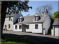
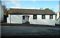
Polnoon Street
This single-storey cottage was restored http://www.geograph.org.uk/photo/2319336 in association with the National Trust for Scotland and one of the first houses in the village to be restored.
Image: © Kenneth Mallard
Taken: 22 May 2010
0.00 miles
2
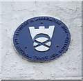
National Trust for Scotland small houses restoration plaque
A cottage http://www.geograph.org.uk/photo/1871213 in Polnoon Street was one of the first houses to be restored in Eaglesham. A plaque indicates that this single-storey cottage was restored in association with the National Trust for Scotland.
Image: © Kenneth Mallard
Taken: 22 Mar 2011
0.00 miles
3
Polnoon Street at Glendinning Place
Polnoon Street at Glendinning Place looking up to Quarry Lane http://www.geograph.org.uk/photo/1424767 . One of the buildings in Glendinning Place was once a Secession Church of the Burgher faction. The Patronage Act of 1712 gave the local laird or landowner the right to appoint the Minister of his Parish. Following much ill-feeling, the Secession Church broke away from the established church in 1733. Sometime after the church closed, the meeting house became the Old Concert Hall for a time before being converted to a private residence. Links to other views of Polnoon Street http://www.geograph.org.uk/photo/1450275 http://www.geograph.org.uk/photo/1480585 .
Image: © Kenneth Mallard
Taken: 2 Aug 2009
0.00 miles
4
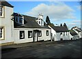
Cottages on Polnoon Street
The nearest cottage, with the dormer windows is Category B listed http://portal.historicenvironment.scot/designation/LB5218.
Image: © Richard Sutcliffe
Taken: 7 Mar 2022
0.01 miles
6
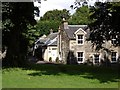
Quarry Lane from the Orry
Quarry Lane once led to a whinstone quarry that was situated behind the houses on Polnoon Street. A track continued on to Moorhouse following what is now Kirktonmoor Road. The cottage in the foreground has two wall dormers typical of buildings in the village. Today the lane leads to a private housing development at Bonnyton Drive.
Image: © Kenneth Mallard
Taken: 2 Aug 2009
0.01 miles
7
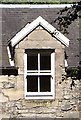
Wall dormer
One of a pair of wall dormers on a house in Polnoon Street.
Image: © Kenneth Mallard
Taken: 2 Aug 2009
0.01 miles
8
Houses on Polnoon Street
Category B listed http://portal.historicenvironment.scot/designation/LB5218.
Image: © Richard Sutcliffe
Taken: 7 Mar 2022
0.01 miles
9
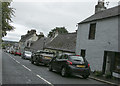
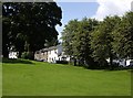
Eaglesham village
A fairly steep hill down through the village as the road descends from the wind farm.
Image: © Malcolm Neal
Taken: 22 Aug 2018
0.01 miles
10
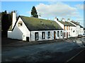
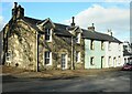
Houses on Polnoon Street
Originally a two-storey house dated 1796, the nearer property was reduced to a single-storey building in 1956. It and the adjoining properties are Category B listed http://portal.historicenvironment.scot/designation/LB5217.
Image: © Richard Sutcliffe
Taken: 7 Mar 2022
0.03 miles