IMAGES TAKEN NEAR TO
Hill Drive, GLASGOW, G76 0AL
Introduction
This page details the photographs taken nearby to Hill Drive, G76 0AL by members of the Geograph project.
The Geograph project started in 2005 with the aim of publishing, organising and preserving representative images for every square kilometre of Great Britain, Ireland and the Isle of Man.

There are currently over 7.5m images from over14,400 individuals and you can help contribute to the project by visiting https://www.geograph.org.uk
Image Map
Images are licensed for reuse under creativecommons.org/licenses/by-sa/2.0
Notes
- Clicking on the map will re-center to the selected point.
- The higher the marker number, the further away the image location is from the centre of the postcode.
Image Listing (79 Images Found)
Images are licensed for reuse under creativecommons.org/licenses/by-sa/2.0
Image
Details
Distance
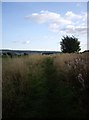
1
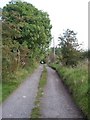
The Weavers' Trail at Kirk Wynd
The Weavers' Trail follows the track along Kirk Wynd near Brownmuir Holdings. Click on this link to proceed to Brownmuir Holdings http://www.geograph.org.uk/photo/1493877 or to return to Eaglesham http://www.geograph.org.uk/photo/1450602 and discover about the Weavers' Trail http://www.geograph.org.uk/article/The-Darvel-to-Eaglesham-weavers-trail .
Image: © Kenneth Mallard
Taken: 15 Sep 2009
0.07 miles
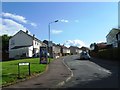
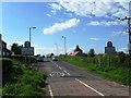
3
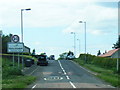
Strathaven Road at Eaglesham village boundary
Image: © Colin Pyle
Taken: 4 Jun 2013
0.13 miles
4
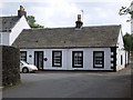
Montgomery Square
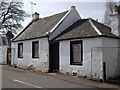
Montgomery Square was once the High Street of the mediaeval village. A single-storey cottage in Montgomery Square built by 1789. The 1861 census indicates that Jonathan Kennedy, a shoemaker and his wife, Helen Kennedy, a handloom cotton weaver resided in the cottage. The emunerator, James B. Yuille describes Montgomery Square as "... Backrow (known also as Montgomerie Square which name is not properly applied as neither the ground nor the houses form a square)..."
Image: © Kenneth Mallard
Taken: 4 Jun 2010
0.15 miles
5
The Weavers' Trail near Brownmuir Holdings, Picketlaw
The Weavers' Trail http://www.geograph.org.uk/article/The-Darvel-to-Eaglesham-weavers-trail follows a path across farmland at Picketlaw near Brownmuir Holdings. Click on this link to proceed to the next point on the journey past Picketlaw http://www.geograph.org.uk/photo/1986033 or to return to Eaglesham http://www.geograph.org.uk/photo/1450602 .
Image: © Kenneth Mallard
Taken: 15 Sep 2009
0.15 miles
6
Montgomery Square
Montgomery Square bounds two sides of Eaglesham Parish kirkyard and was once the High Street. Gas works were situated in Gas Works Lane which 19th century maps show to be Kirk Wynd which leads off Montgomery Square beside the cottage pictured in the background. Kirk Wynd is known locally as Gassy Brae in reference to the gas works that were once situated here. The Darvel and Newmilns weavers used to make the 16 mile journey from Darvel to Eaglesham on occasion carrying a piece of finished cloth for the markets and collecting a new clue of yarn which would arrive with the carriers from Glasgow and Paisley. The Weavers' Trail http://www.geograph.org.uk/article/The-Darvel-to-Eaglesham-weavers-trail starts or finishes depending on the direction of travel at Montgomery Square following a route along Kirk Wynd http://www.geograph.org.uk/photo/1490402 ; passing Park Farm http://www.geograph.org.uk/photo/1490436 http://www.geograph.org.uk/photo/1490362 ; Netherton, Carrot http://www.geograph.org.uk/photo/1434824 ; Myres Hill http://www.geograph.org.uk/photo/1434824 Crook Hill http://www.geograph.org.uk/photo/89608 ; High Overmuir http://www.geograph.org.uk/photo/89605 ; Auldhouse Burn http://www.geograph.org.uk/photo/89604 ; Low Overmuir Farm Road http://www.geograph.org.uk/photo/89602 ; Pogiven Bridge http://www.geograph.org.uk/photo/89600 ; track to High Carlingcraig http://www.geograph.org.uk/photo/240520 before descending to Darvel http://www.geograph.org.uk/photo/78857 . Click on this link to discover about the Eaglesham cotton mills http://www.geograph.org.uk/photo/1450337 .
Image: © Kenneth Mallard
Taken: 20 Aug 2009
0.15 miles
8
Montgomery Square
Montgomery Square lies between Montgomery Street at the Cross Keys Inn http://www.geograph.org.uk/photo/1450299 and Gilmour Street. The churchyard of Eaglesham Parish Church is situated behind the wall on the left of the photograph.
Image: © Kenneth Mallard
Taken: 7 Sep 2009
0.16 miles
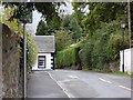
9
Cross Keys cottage
Cross Keys cottage in Montgomery Square is recorded as being tacked to Robert Montgomerie in June 1773. John Arneil later owned the cottage and Cross Keys Inn http://www.geograph.org.uk/photo/1875376 for many years.
Image: © Kenneth Mallard
Taken: 24 Apr 2010
0.16 miles
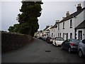
10
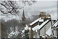
Eaglesham in the Snow
Looking dow Montgomery Street towards the spire of Eaglesham Parish Church in the snow.
Image: © Stewart Macfarlane
Taken: 12 Mar 2006
0.17 miles