IMAGES TAKEN NEAR TO
Strathaven Road, GLASGOW, G76 0AG
Introduction
This page details the photographs taken nearby to Strathaven Road, G76 0AG by members of the Geograph project.
The Geograph project started in 2005 with the aim of publishing, organising and preserving representative images for every square kilometre of Great Britain, Ireland and the Isle of Man.

There are currently over 7.5m images from over14,400 individuals and you can help contribute to the project by visiting https://www.geograph.org.uk
Image Map
Images are licensed for reuse under creativecommons.org/licenses/by-sa/2.0
Notes
- Clicking on the map will re-center to the selected point.
- The higher the marker number, the further away the image location is from the centre of the postcode.
Image Listing (13 Images Found)
Images are licensed for reuse under creativecommons.org/licenses/by-sa/2.0
Image
Details
Distance
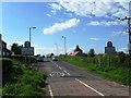
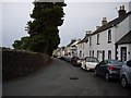
2
Strathaven Road at Eaglesham village boundary
Image: © Colin Pyle
Taken: 4 Jun 2013
0.02 miles
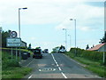
6
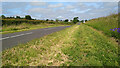
Well-cut verges on the road into Eaglesham
Image: © Gordon Brown
Taken: 30 Jun 2021
0.17 miles
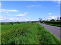
7
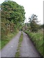
The Weavers' Trail at Kirk Wynd
The Weavers' Trail follows the track along Kirk Wynd near Brownmuir Holdings. Click on this link to proceed to Brownmuir Holdings http://www.geograph.org.uk/photo/1493877 or to return to Eaglesham http://www.geograph.org.uk/photo/1450602 and discover about the Weavers' Trail http://www.geograph.org.uk/article/The-Darvel-to-Eaglesham-weavers-trail .
Image: © Kenneth Mallard
Taken: 15 Sep 2009
0.18 miles
8
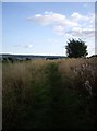
The Weavers' Trail near Brownmuir Holdings, Picketlaw
The Weavers' Trail http://www.geograph.org.uk/article/The-Darvel-to-Eaglesham-weavers-trail follows a path across farmland at Picketlaw near Brownmuir Holdings. Click on this link to proceed to the next point on the journey past Picketlaw http://www.geograph.org.uk/photo/1986033 or to return to Eaglesham http://www.geograph.org.uk/photo/1450602 .
Image: © Kenneth Mallard
Taken: 15 Sep 2009
0.19 miles
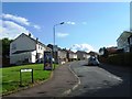
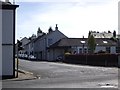
9
Montgomery Square
Montgomery Square lies between Montgomery Street at the Cross Keys Inn http://www.geograph.org.uk/photo/1450299 and Gilmour Street. The churchyard of Eaglesham Parish Church is situated behind the wall on the left of the photograph.
Image: © Kenneth Mallard
Taken: 7 Sep 2009
0.22 miles
10
Gilmour Street
Eaglesham Cross looking along Gilmour Street. Kirkstyle, a single-storey cottage believed to be of seventeenth century origin is situated to the right of Cross Garage in the foreground. Links to other views of Gilmour Street http://www.geograph.org.uk/photo/1484257 http://www.geograph.org.uk/photo/1484265 .
Image: © Kenneth Mallard
Taken: 12 Sep 2009
0.23 miles