IMAGES TAKEN NEAR TO
Germiston Court, GLASGOW, G75 9LP
Introduction
This page details the photographs taken nearby to Germiston Court, G75 9LP by members of the Geograph project.
The Geograph project started in 2005 with the aim of publishing, organising and preserving representative images for every square kilometre of Great Britain, Ireland and the Isle of Man.

There are currently over 7.5m images from over14,400 individuals and you can help contribute to the project by visiting https://www.geograph.org.uk
Image Map
Images are licensed for reuse under creativecommons.org/licenses/by-sa/2.0
Notes
- Clicking on the map will re-center to the selected point.
- The higher the marker number, the further away the image location is from the centre of the postcode.
Image Listing (7 Images Found)
Images are licensed for reuse under creativecommons.org/licenses/by-sa/2.0
Image
Details
Distance
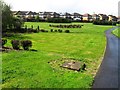
2
Burn, Lindsayfield
A green space amongst the new houses.
Image: © Richard Webb
Taken: 1 Aug 2014
0.15 miles
3
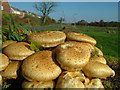
Fungi on a tree stump.
Magnificent growth that lasted for weeks. People still preferred the local Morrisons though!
Image: © Steve woodward
Taken: 27 Oct 2005
0.19 miles
4
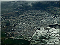
East Kilbride from the air
Looking over Lindsayfield from an Amsterdam bound flight from Glasgow.
Image: © Thomas Nugent
Taken: 2 Mar 2015
0.19 miles
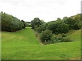
5
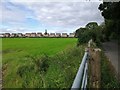
Lindsayfield houses and pasture
Lindsayfield is a fairly new housing estate on the south edge of East Kilbride, next to farmland. The country road seen here runs along the south edge of Lindsayfield.
Image: © Alec MacKinnon
Taken: 28 Aug 2020
0.22 miles
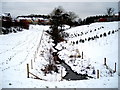
6
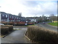
Crosshouse Road
Looking down Crosshouse Road, at the entrance to Eider Avenue.
Image: © Melissa Gray
Taken: 27 Feb 2008
0.23 miles