IMAGES TAKEN NEAR TO
Vancouver Drive, GLASGOW, G75 8LQ
Introduction
This page details the photographs taken nearby to Vancouver Drive, G75 8LQ by members of the Geograph project.
The Geograph project started in 2005 with the aim of publishing, organising and preserving representative images for every square kilometre of Great Britain, Ireland and the Isle of Man.

There are currently over 7.5m images from over14,400 individuals and you can help contribute to the project by visiting https://www.geograph.org.uk
Image Map
Images are licensed for reuse under creativecommons.org/licenses/by-sa/2.0
Notes
- Clicking on the map will re-center to the selected point.
- The higher the marker number, the further away the image location is from the centre of the postcode.
Image Listing (19 Images Found)
Images are licensed for reuse under creativecommons.org/licenses/by-sa/2.0
Image
Details
Distance
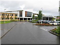
1
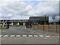
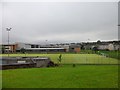
East Milton Primary School
A new building in East Kilbride.
Image: © Richard Webb
Taken: 1 Aug 2014
0.11 miles
2
Alberta Avenue, East Kilbride
The land on the right was formerly the site of Duncanrig Secondary School. Now it is occupied by a recent development of private housing.
Image: © G Laird
Taken: 2 Oct 2012
0.13 miles
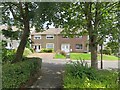
3
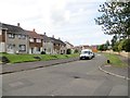
Alberta Avenue
Residential area, East Kilbride.
Image: © Richard Webb
Taken: 1 Aug 2014
0.14 miles
4
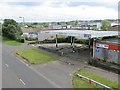
Closed garage, East Kilbride
Seen from a bridge taking a path over the A726.
Image: © Richard Webb
Taken: 1 Aug 2014
0.15 miles
5
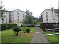
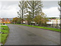
Between Alberta Avenue and Winnipeg Drive
Unlike much of Manitoba and eastern Alberta there is a bit of a gradient here. The flats are at an angle to the slope with a jagged path running between them to a footbridge above.
Image: © Richard Webb
Taken: 1 Aug 2014
0.15 miles
6
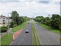
A726
The main road through East Kilbride and home to many a queue featuring in the traffic reports. View from an all too rare footbridge.
Image: © Richard Webb
Taken: 1 Aug 2014
0.16 miles
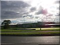
7
Duncanrig Secondary School
A new school building officially opened in 2008 built on the site of the playing fields of the original building.
Image: © G Laird
Taken: 2 Oct 2012
0.17 miles
8
Duncanrig Secondary School, East Kilbride
Image: © Elliott Simpson
Taken: 5 Aug 2011
0.18 miles
9
Duncanrig Secondary School, East Kilbride
From Westwood Road.
Image: © Stephen Sweeney
Taken: 5 Jul 2012
0.19 miles
10
Lindores Drive
Residential area north of the A726. I was looking for the footbridge at this time.
Image: © Richard Webb
Taken: 1 Aug 2014
0.20 miles