IMAGES TAKEN NEAR TO
Tasman Drive, GLASGOW, G75 8EX
Introduction
This page details the photographs taken nearby to Tasman Drive, G75 8EX by members of the Geograph project.
The Geograph project started in 2005 with the aim of publishing, organising and preserving representative images for every square kilometre of Great Britain, Ireland and the Isle of Man.

There are currently over 7.5m images from over14,400 individuals and you can help contribute to the project by visiting https://www.geograph.org.uk
Image Map
Images are licensed for reuse under creativecommons.org/licenses/by-sa/2.0
Notes
- Clicking on the map will re-center to the selected point.
- The higher the marker number, the further away the image location is from the centre of the postcode.
Image Listing (12 Images Found)
Images are licensed for reuse under creativecommons.org/licenses/by-sa/2.0
Image
Details
Distance
1
Spar East Kilbride
A Spar store in Westwood.
Image: © Ross Watson
Taken: 10 Sep 2012
0.14 miles
2
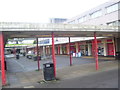
Redcliffe Drive Restaurant
A restaurant and William Hill Bookmakers on Redcliffe Drive.
Image: © Ross Watson
Taken: 10 Sep 2012
0.14 miles
3
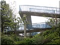
Westwood Footbridge
A footbridge over Westwood Road.
Image: © Ross Watson
Taken: 10 Sep 2012
0.15 miles
4
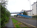
Footbridge, Westwood Road
A lot of extra effort for those climbing up the slope from Alberta Avenue and big railings make sure that you climb the bridge. A problem for me as I wanted to get on to Westwood Road, but there has to be a gap in the defences at a bus stop and I was soon free.
Image: © Richard Webb
Taken: 1 Aug 2014
0.16 miles
5
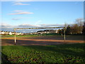
Football Pitches
Football pitches, near Westwood, East Kilbride
Image: © Iain Thompson
Taken: 4 Dec 2005
0.17 miles
6
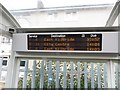
Bus stop, Westwood Road
Destination board and No campaign sticker in a bus shelter. The bus stop was useful as it allowed me to get off the pavement and back on the road again - the fencing is ferocious here.
Image: © Richard Webb
Taken: 1 Aug 2014
0.17 miles
7
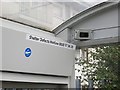
Bus stop, Westwood Road
CCTV everywhere, yet I have been questioned four times, three at home by the police for taking still photographs - of fields.
And while we are at it: that is a No campaign sticker from the 2014 independence referendum, which is good, because you needed a thick skin to post pictures of Yes material on here at that time.
Image: © Richard Webb
Taken: 1 Aug 2014
0.17 miles
8
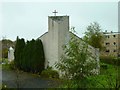
Lutheran Church St Columba
View of the back of the church on Westwood Hill in East Kilbride.
Image: © Andy Farrington
Taken: 8 Oct 2011
0.19 miles
9
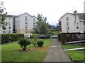
Between Alberta Avenue and Winnipeg Drive
Unlike much of Manitoba and eastern Alberta there is a bit of a gradient here. The flats are at an angle to the slope with a jagged path running between them to a footbridge above.
Image: © Richard Webb
Taken: 1 Aug 2014
0.21 miles
10
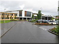
Duncanrig Secondary School
A new school building officially opened in 2008 built on the site of the playing fields of the original building.
Image: © G Laird
Taken: 2 Oct 2012
0.23 miles