IMAGES TAKEN NEAR TO
Torrance Lane, GLASGOW, G75 0RX
Introduction
This page details the photographs taken nearby to Torrance Lane, G75 0RX by members of the Geograph project.
The Geograph project started in 2005 with the aim of publishing, organising and preserving representative images for every square kilometre of Great Britain, Ireland and the Isle of Man.

There are currently over 7.5m images from over14,400 individuals and you can help contribute to the project by visiting https://www.geograph.org.uk
Image Map
Images are licensed for reuse under creativecommons.org/licenses/by-sa/2.0
Notes
- Clicking on the map will re-center to the selected point.
- The higher the marker number, the further away the image location is from the centre of the postcode.
Image Listing (23 Images Found)
Images are licensed for reuse under creativecommons.org/licenses/by-sa/2.0
Image
Details
Distance
1

New housing off the Torrance roundabout
At time of submitting, the OS 50,000 mapping had not quite caught up with the housbuilders' new roads.
Image: © Gordon Brown
Taken: 11 Feb 2008
0.16 miles
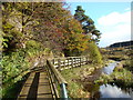
2
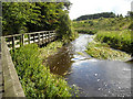
Calder Water
Calder Water with Calderglen footpath from Langlands on left
Image: © Iain Thompson
Taken: 10 Aug 2008
0.17 miles
3
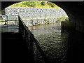
Calder Water
Calder Water passing under the A726
Image: © Iain Thompson
Taken: 10 Aug 2008
0.17 miles
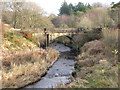
4
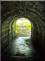
Foot path under Bridge over Calder Water
Footpath under the old bridge over Calder Water
Image: © Iain Thompson
Taken: 10 Aug 2008
0.19 miles
7
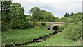
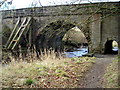
Flatt Bridge
Old road bridge over the Calder Water. The road between East Kilbride and Strathaven has been realighned and smoothed out and this bridge has been replaced by a new bridge to the west.
Image: © Richard Webb
Taken: 4 Jun 2012
0.19 miles
8
Flatt Bridge
Prior to the realignment many years ago of the A726 (East Kilbride to Strathaven Road) and the construction of a new bridge, Flatt Bridge formerly carried the A726 across the Calder Water.
Image: © G Laird
Taken: 26 Nov 2012
0.20 miles
9
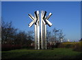
The Ks
This monument is at the edge of the Kelvin Industrial Estate, East Kilbride, at the junction of Greenhills Road and Strathaven Road.
Image: © Iain Thompson
Taken: 24 Dec 2005
0.20 miles
10
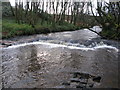
Small waterfall on the Calder Water
Just down river from Flatt Bridge.
Image: © G Laird
Taken: 19 Jan 2014
0.21 miles