IMAGES TAKEN NEAR TO
East Kilbride, GLASGOW, G75 0QN
Introduction
This page details the photographs taken nearby to G75 0QN by members of the Geograph project.
The Geograph project started in 2005 with the aim of publishing, organising and preserving representative images for every square kilometre of Great Britain, Ireland and the Isle of Man.

There are currently over 7.5m images from over14,400 individuals and you can help contribute to the project by visiting https://www.geograph.org.uk
Image Map
Images are licensed for reuse under creativecommons.org/licenses/by-sa/2.0
Notes
- Clicking on the map will re-center to the selected point.
- The higher the marker number, the further away the image location is from the centre of the postcode.
Image Listing (12 Images Found)
Images are licensed for reuse under creativecommons.org/licenses/by-sa/2.0
Image
Details
Distance
1
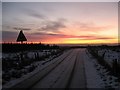
Dawn breaks on the road over Ardrochrig hill
A cold, frosty, snowy but beautiful December morning travelling SW on the road over Ardrochrig hill. Just past the entrance to Whitelee Forest and the wind farm.
Image: © Steve woodward
Taken: 7 Dec 2008
0.12 miles
2

Road south of Ardochrig Farm
The road over Ardochrig is popular with local cyclists, giving a wee steep climb on its north side or a longer ascent on the south side. The view here looks south along the road just below Ardochrig Farm.
Image: © Alec MacKinnon
Taken: 18 Nov 2012
0.16 miles
3
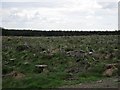
Felled block, Whitelee
Opposite the substation.
Image: © Richard Webb
Taken: 4 Jun 2012
0.18 miles
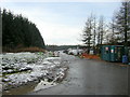
5
Whitelee Forest from Ardochrig Road
Whitelee Forest and recycling bin.
Image: © Iain Thompson
Taken: 14 Oct 2005
0.19 miles
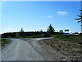
6

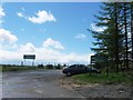
Car parking at Ardochrig
This is one of the entrances to the Whitelee Wind Farm. There is space for around 12 to 15 cars here and at 0930 on New Year's Day, all spaces were taken. When I returned here after a long walk, at 1500, there must have been 60 cars parked here and along the verges of the single-track approach road.
Image: © Gordon Brown
Taken: 1 Jan 2021
0.20 miles
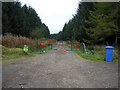
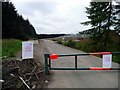
8
Entrance to Whitelee Wind Farm Construction Site
Almost the same view as the first geograph for this square but looks onto construction site rather than forest.
Image: © Iain Thompson
Taken: 19 Nov 2006
0.22 miles
9
Entrance to the Whitelee Wind Farm
The main electricity switching station can be seen behind to the right. The wind farm is already generating although it is not scheduled for completion until September 2009.
Image: © Gordon Brown
Taken: 16 May 2008
0.22 miles
10
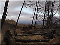
Felled trees at the entrance to Whitelee Windfarm
Much of the forest has been felled here recently. There is still a sparse clump of trees on the south side of the rough road as it enters the forest and the windfarm. This view looks north through the trees, some recently felled, with Eastern Glasgow and East Kilbride just visible beyond.
Image: © Alec MacKinnon
Taken: 13 Feb 2011
0.24 miles