IMAGES TAKEN NEAR TO
Pineta Drive, GLASGOW, G74 5EB
Introduction
This page details the photographs taken nearby to Pineta Drive, G74 5EB by members of the Geograph project.
The Geograph project started in 2005 with the aim of publishing, organising and preserving representative images for every square kilometre of Great Britain, Ireland and the Isle of Man.

There are currently over 7.5m images from over14,400 individuals and you can help contribute to the project by visiting https://www.geograph.org.uk
Image Map
Images are licensed for reuse under creativecommons.org/licenses/by-sa/2.0
Notes
- Clicking on the map will re-center to the selected point.
- The higher the marker number, the further away the image location is from the centre of the postcode.
Image Listing (8 Images Found)
Images are licensed for reuse under creativecommons.org/licenses/by-sa/2.0
Image
Details
Distance
2
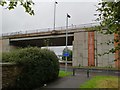
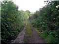
Footpath near Philipshill
The pedestrian and cycle path runs through the trees from Bardana Road, on the western edge of East Kilbride. At this point it runs up against the A726, which is carried by the viaduct behind. The blue signs send cyclists right, along the pavement, if they want to make their way to East Kilbride, or along the path through the trees if they are heading for Thorntonhall or Eaglesham.
Image: © Alec MacKinnon
Taken: 7 Sep 2020
0.16 miles
3
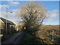
Lane near Thorntonhall
The lane runs north from Braehad, on the edge of Thorntonhall, to the A727 where it comes to a dead end. Across the field at right new houses are being built, East Kilbride continuing its expansion into the surrounding farmland.
Image: © Alec MacKinnon
Taken: 15 Dec 2020
0.17 miles
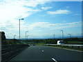
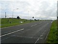
5

The end of the new Southern Orbital Road (A726)
The roundabout at the end of the new road which was opened in May 2005.
Image: © G McK
Taken: 11 Jun 2005
0.20 miles
6
Track towards the A727
Heading north from Braehead.
Image: © Stephen Sweeney
Taken: 16 Sep 2009
0.22 miles
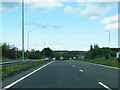
7
A727 nearing East Kilbride
Looking east towards the town.
Image: © Stephen Sweeney
Taken: 16 Sep 2009
0.23 miles
8
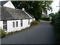
Houses by Braehead Road
Heading from Thorntonhall into Braehead.
Image: © Stephen Sweeney
Taken: 16 Sep 2009
0.24 miles