IMAGES TAKEN NEAR TO
Spittal Road, GLASGOW, G73 4QF
Introduction
This page details the photographs taken nearby to Spittal Road, G73 4QF by members of the Geograph project.
The Geograph project started in 2005 with the aim of publishing, organising and preserving representative images for every square kilometre of Great Britain, Ireland and the Isle of Man.

There are currently over 7.5m images from over14,400 individuals and you can help contribute to the project by visiting https://www.geograph.org.uk
Image Map (Loading...)


Getting Data...Please wait
Leaflet Map data © OpenStreetMap
Images are licensed for reuse under creativecommons.org/licenses/by-sa/2.0
Notes
- Clicking on the map will re-center to the selected point.
- The higher the marker number, the further away the image location is from the centre of the postcode.
Image Listing (20 Images Found)
Images are licensed for reuse under creativecommons.org/licenses/by-sa/2.0
Image
Details
Distance
1
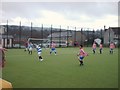
Spittal Primary F.C.
Soccer tournament at Spittal Primary School.
Image: © Lynn M Reid
Taken: 27 Mar 2008
0.11 miles
2
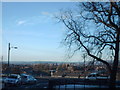
Glasgow Horizon
View towards Glasgow. If you look close, centre left on the horizon is Ben Lomond
Image: © Lynn M Reid
Taken: 4 Mar 2008
0.11 miles

5
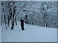
Is this Narnia?
Taken in the small wood behind St. Barts RC Church
Image: © Lynn M Reid
Taken: 12 Mar 2006
0.15 miles
6

Croftfoot Drive and Croftfoot Road
Croftfoot Drive is in the foreground and Croftfoot Road, a main thoroughfare, is beyond. Tenements typical of the Castlemilk area are on the other side of Croftfoot Road.
Image: © Alec MacKinnon
Taken: 20 May 2018
0.17 miles

8
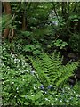
Plants and flowers in Castlemilk Park
Castlemilk Park is wooded and shady. Wild garlic and bluebells are both in bloom just now, all the way along the paths that follows the burn.
Image: © Alec MacKinnon
Taken: 20 May 2018
0.18 miles
9
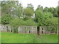
Gap in the fence
Bowhouse Drive, like most recent housing developments is a strict cul-de-sac with possible through routes designed out. This of course means that the residents cannot get at the attractive woodland path next door. That problem has been addressed.
Image: © Richard Webb
Taken: 10 May 2014
0.20 miles
10

Bowhouse Drive
Newish and anonymous housing development. The stated location is correct, this really is NS6159 despite appearances.
Image: © Richard Webb
Taken: 10 May 2014
0.21 miles