IMAGES TAKEN NEAR TO
Alloway Drive, GLASGOW, G73 4PP
Introduction
This page details the photographs taken nearby to Alloway Drive, G73 4PP by members of the Geograph project.
The Geograph project started in 2005 with the aim of publishing, organising and preserving representative images for every square kilometre of Great Britain, Ireland and the Isle of Man.

There are currently over 7.5m images from over14,400 individuals and you can help contribute to the project by visiting https://www.geograph.org.uk
Image Map
Images are licensed for reuse under creativecommons.org/licenses/by-sa/2.0
Notes
- Clicking on the map will re-center to the selected point.
- The higher the marker number, the further away the image location is from the centre of the postcode.
Image Listing (17 Images Found)
Images are licensed for reuse under creativecommons.org/licenses/by-sa/2.0
Image
Details
Distance
1

Houses on Kirkconnel Drive
Mono-pitched roofs, viewed across the former Spittal Sports Ground. The wind turbine is at Cathkin Braes.
Image: © Thomas Nugent
Taken: 27 May 2017
0.11 miles
3

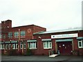
Spittal Primary F.C.
Soccer tournament at Spittal Primary School.
Image: © Lynn M Reid
Taken: 27 Mar 2008
0.13 miles
5
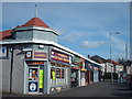
Shops on Castlemilk Road
In Croftfoot.
Image: © Thomas Nugent
Taken: 27 May 2017
0.14 miles
6
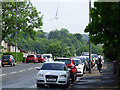
Castlemilk Road
Looking up the hill near Croftside Avenue. The wind turbine is at Cathkin Braes.
Image: © Thomas Nugent
Taken: 27 May 2017
0.14 miles
8

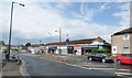
Croftfoot Drive and Croftfoot Road
Croftfoot Drive is in the foreground and Croftfoot Road, a main thoroughfare, is beyond. Tenements typical of the Castlemilk area are on the other side of Croftfoot Road.
Image: © Alec MacKinnon
Taken: 20 May 2018
0.19 miles
9
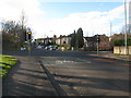
Crossroads in Croftfoot
Looking along Croftfoot Road at the intersection with Castlemilk Road.
Image: © G Laird
Taken: 27 Nov 2012
0.21 miles
10
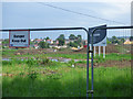
Former Spittal Sports Ground
Finally succumbed to housing development following fifteen years of dereliction and debate.
Image: © Thomas Nugent
Taken: 27 May 2017
0.23 miles