IMAGES TAKEN NEAR TO
Rowantree Avenue, GLASGOW, G73 4NB
Introduction
This page details the photographs taken nearby to Rowantree Avenue, G73 4NB by members of the Geograph project.
The Geograph project started in 2005 with the aim of publishing, organising and preserving representative images for every square kilometre of Great Britain, Ireland and the Isle of Man.

There are currently over 7.5m images from over14,400 individuals and you can help contribute to the project by visiting https://www.geograph.org.uk
Image Map
Images are licensed for reuse under creativecommons.org/licenses/by-sa/2.0
Notes
- Clicking on the map will re-center to the selected point.
- The higher the marker number, the further away the image location is from the centre of the postcode.
Image Listing (7 Images Found)
Images are licensed for reuse under creativecommons.org/licenses/by-sa/2.0
Image
Details
Distance
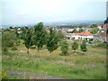
1
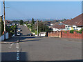
Hillend Road
Looking over the eastern suburbs to the 3 towers at Cranhill.
The road is on National Cycle Route 756.
Image: © wrobison
Taken: 7 Sep 2024
0.07 miles
3
Drumilaw Road
Leads to a residential estate.
Image: © Stephen Sweeney
Taken: 1 Apr 2009
0.18 miles
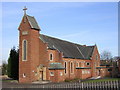
4
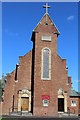
St Mark's Church, Fernhill Road, Rutherglen
Built 1961
Image: © Leslie Barrie
Taken: 9 Aug 2014
0.20 miles
5
To Burnside from Fernhill Park
Looking northwest from the footpath in the informal parkland area between Fernhill and High Burnside. Celtic Park can be seen in the distance
Image: © Graham Crowe
Taken: 8 Jul 2005
0.23 miles
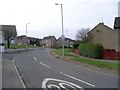
6
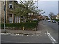
Old road sign by Crawfurd Avenue
The road signposted is now called Blairbeth Road.
Image: © Stephen Sweeney
Taken: 1 Apr 2009
0.24 miles
7
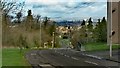
What the boy sees
View looking downhill (North) the towards Rutherglen and Glasgow from the location of the Kenny Hunter statue
Image: © Graham Crowe
Taken: 8 Apr 2014
0.24 miles