IMAGES TAKEN NEAR TO
Glasgow Road, GLASGOW, G73 1SU
Introduction
This page details the photographs taken nearby to Glasgow Road, G73 1SU by members of the Geograph project.
The Geograph project started in 2005 with the aim of publishing, organising and preserving representative images for every square kilometre of Great Britain, Ireland and the Isle of Man.

There are currently over 7.5m images from over14,400 individuals and you can help contribute to the project by visiting https://www.geograph.org.uk
Image Map
Images are licensed for reuse under creativecommons.org/licenses/by-sa/2.0
Notes
- Clicking on the map will re-center to the selected point.
- The higher the marker number, the further away the image location is from the centre of the postcode.
Image Listing (13 Images Found)
Images are licensed for reuse under creativecommons.org/licenses/by-sa/2.0
Image
Details
Distance
1
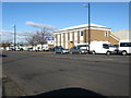
Business premises in Rutherglen
On the road from the town centre to Shawfield.
Image: © James Denham
Taken: 4 Nov 2013
0.03 miles
2
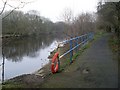
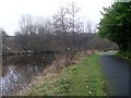
Fenced-off embankment by the Clyde Walkway
The trees do not provide a natural fence at this section.
Image: © Stephen Sweeney
Taken: 18 Feb 2009
0.14 miles
3
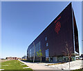
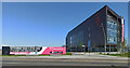
Red Tree at Magenta
Red Tree offers business accommodation under the Clyde Gateway regeneration programme https://investinclydegateway.com/ .
Image: © Thomas Nugent
Taken: 22 Apr 2022
0.15 miles
4
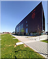
Red Tree at magenta
Red Tree offers business accommodation under the Clyde Gateway regeneration programme https://investinclydegateway.com/ .
Image: © Thomas Nugent
Taken: 22 Apr 2022
0.15 miles
5
Red Tree at Magenta
Red Tree offers business accommodation under the Clyde Gateway regeneration programme https://investinclydegateway.com/ .
Image: © Thomas Nugent
Taken: 22 Apr 2022
0.16 miles
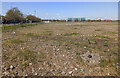
8
Clyde Gateway development land
Brownfield site with Police Scotland on the left, Celtic park in the distance (right of the trees) and the former Strathclyde School on the right.
Part of the Clyde Gateway regeneration programme https://investinclydegateway.com/ .
Image: © Thomas Nugent
Taken: 22 Apr 2022
0.19 miles
9
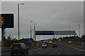
Approaching meander in the River Clyde
Along the Clyde Walkway in Dalmarnock.
Image: © Stephen Sweeney
Taken: 18 Feb 2009
0.22 miles
10
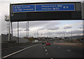
Clyde Gateway development land
Brownfield site with Police Scotland in the distance and one of the Shawfield Stadium floodlight pylons on the left.
Part of the Clyde Gateway regeneration programme https://investinclydegateway.com/ .
Image: © Thomas Nugent
Taken: 22 Apr 2022
0.22 miles