IMAGES TAKEN NEAR TO
Rutherglen Links, GLASGOW, G73 1DF
Introduction
This page details the photographs taken nearby to Rutherglen Links, G73 1DF by members of the Geograph project.
The Geograph project started in 2005 with the aim of publishing, organising and preserving representative images for every square kilometre of Great Britain, Ireland and the Isle of Man.

There are currently over 7.5m images from over14,400 individuals and you can help contribute to the project by visiting https://www.geograph.org.uk
Image Map
Images are licensed for reuse under creativecommons.org/licenses/by-sa/2.0
Notes
- Clicking on the map will re-center to the selected point.
- The higher the marker number, the further away the image location is from the centre of the postcode.
Image Listing (91 Images Found)
Images are licensed for reuse under creativecommons.org/licenses/by-sa/2.0
Image
Details
Distance
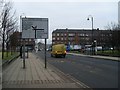
1
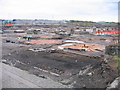
Caledonian Pottery excavations, Rutherglen
During 2007, in advance of the forthcoming destructive passage of the M74 motorway extension, an archaeological consortium was busy uncovering historical evidence of the previous use of land in Rutherglen and at other sites across the south of Glasgow. This was the former Caledonian Pottery in the angle between the main Glasgow - Carlisle railway and Farmeloan Road. The pottery was opened on this site between 1870 and 1872 and made a wide ranger of products, including teapots, bowls and stoneware jugs. In 1898 it was bought by jam-makers W.P.Hartley to ensure a supply of stone jamjars but closed in 1928 when glass jars became common. The pottery was demolished and the ground level raised some four feet on concrete to support the Caledonian Steelworks, built on the site in 1930. This in turn closed in the early 1960s. The orange circles in the foreground are the bases of kilns where the pottery was fired, the white square to their left being the foundation of a chimney to take away the hot fumes from the firing. The square plinths beyond them are part of the foundations of the later steelworks, some still sprouting cut-off girders. The white area to the left of the orange barriers was the potters' workshop in which the jars, etc. were moulded from clay. In the bottom corner was the exit road from the pottery yard, the stone slabs at right-angles to the setts being arranged to give a smooth passage for cart-wheels and ease the burden on the carthorses.
Image: © A-M-Jervis
Taken: 20 Oct 2007
0.07 miles
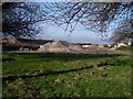
2
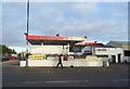
Car wash on Farmeloan Road (A749), Rutherglen
Image: © JThomas
Taken: 16 Sep 2021
0.08 miles
3
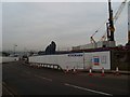
M74 extension, Rutherglen
Construction has started on a project which has been dead since 1974 - the extension of the M74 from its current terminal point at Carmyle to meet with the M8 at Tradeston.
Image: © Stephen Sweeney
Taken: 18 Feb 2009
0.08 miles
4
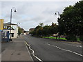
Approaching Farme Cross on Farmeloan Road
Approaching the junction at Cambuslang Road in Dalmarnock.
Image: © Stephen Sweeney
Taken: 18 Feb 2009
0.08 miles
5

Definition of irony?
A billboard encouraging protection of the environment, right beside the construction of a new motorway. Environmentalist or no, one has to see the funny side!
Image: © Stephen Sweeney
Taken: 1 Apr 2009
0.09 miles
6
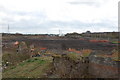
M74 extension
This is waste ground at present,the M74 motorway extension will go straight through here.To the right of frame,you can see the cable pylons for the main railway line.This is the former site of the Caledonian pottery.
Image: © Scott
Taken: 24 Apr 2008
0.09 miles
7
Rubble from M74 construction
Beside Cambuslang Road.
Image: © Stephen Sweeney
Taken: 1 Apr 2009
0.09 miles
8
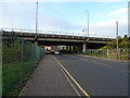
M74 Motorway bridge over Farmeloan Road (A749), Rutherglen
Image: © JThomas
Taken: 16 Sep 2021
0.09 miles
9

New motorway bridge over Farmeloan Road
Will carry the extended M74. Some progress from my last visit here just six weeks ago, when this bridge was non-existent.
Image: © Stephen Sweeney
Taken: 1 Apr 2009
0.10 miles