IMAGES TAKEN NEAR TO
Booth Walk, GLASGOW, G72 7EW
Introduction
This page details the photographs taken nearby to Booth Walk, G72 7EW by members of the Geograph project.
The Geograph project started in 2005 with the aim of publishing, organising and preserving representative images for every square kilometre of Great Britain, Ireland and the Isle of Man.

There are currently over 7.5m images from over14,400 individuals and you can help contribute to the project by visiting https://www.geograph.org.uk
Image Map (Loading...)


Getting Data...Please wait
Leaflet Map data © OpenStreetMap
Images are licensed for reuse under creativecommons.org/licenses/by-sa/2.0
Notes
- Clicking on the map will re-center to the selected point.
- The higher the marker number, the further away the image location is from the centre of the postcode.
Image Listing (20 Images Found)
Images are licensed for reuse under creativecommons.org/licenses/by-sa/2.0
Image
Details
Distance
1
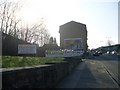
Hoover, Cambuslang
View over the Clyde to a factory under demolition, as is usually the case with factories these days. The closure was announced in 2003.
Image: © Richard Webb
Taken: 25 Jul 2008
0.09 miles
2
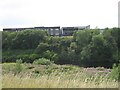
Clyde Walkway and cycleway No75 near Carmyle
Image: © Chris Wimbush
Taken: 18 Feb 2007
0.10 miles
3
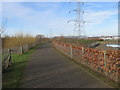
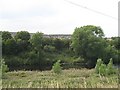
Cambuslang Industrial Estate during development
The undeveloped area is the one that is shown in front of (that is, to the south of) the building in Image Both pictures were taken on the same excursion in 2006. The view is from the cycle path, and the power lines allow the viewpoint to be determined fairly accurately.
Fourteen years later, when this picture was submitted, the cleared ground shown here had long since been occupied by additional buildings of the industrial estate.
Image: © Lairich Rig
Taken: 3 Feb 2006
0.15 miles
4
Cambuslang Karting
Go Karting on the outskirts of Glasgow.
Image: © Stephen Sweeney
Taken: 1 Apr 2009
0.16 miles
5
Hoover, Cambuslang
Demolition of the Hoover factory. View across the Clyde from the Clyde Walkway.
Image: © Richard Webb
Taken: 25 Jul 2008
0.16 miles
6
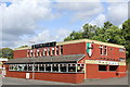
Fratelli, Cambuslang
Italian restaurant on Glasgow Road
Image: © Leslie Barrie
Taken: 9 Aug 2014
0.17 miles
9
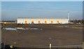
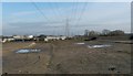
Cambuslang Industrial Estate
Much of the site was still undeveloped when this picture was taken; this view would now be impossible because of intervening buildings. The picture was taken from the nearby cycle path, and the stripes on the building's roof allow the viewpoint to be determined fairly accurately.
The then-undeveloped area in front of the building is shown separately from another angle in Image, taken on the same day. By 2020, when these pictures were submitted, that area had long since been occupied by additional buildings of the industrial estate.
The first-edition map (surveyed in 1858) shows a farm called Bogleshole at about Image, now roughly the northern end of the estate. The Clyde Iron Works Colliery, shown on OS maps from the second edition (1898) onwards, was near Image
The chimney on the right is not part of this building, but belongs to the more distant Image
Image: © Lairich Rig
Taken: 3 Feb 2006
0.19 miles
10
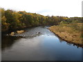
The River Clyde
Heading downstream at Cambuslang.
Image: © James Denham
Taken: 16 Nov 2013
0.20 miles