IMAGES TAKEN NEAR TO
Bramble Wynd, GLASGOW, G72 6WU
Introduction
This page details the photographs taken nearby to Bramble Wynd, G72 6WU by members of the Geograph project.
The Geograph project started in 2005 with the aim of publishing, organising and preserving representative images for every square kilometre of Great Britain, Ireland and the Isle of Man.

There are currently over 7.5m images from over14,400 individuals and you can help contribute to the project by visiting https://www.geograph.org.uk
Image Map
Images are licensed for reuse under creativecommons.org/licenses/by-sa/2.0
Notes
- Clicking on the map will re-center to the selected point.
- The higher the marker number, the further away the image location is from the centre of the postcode.
Image Listing (12 Images Found)
Images are licensed for reuse under creativecommons.org/licenses/by-sa/2.0
Image
Details
Distance
1
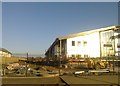
New school being built at Newton Farm
Image: © Elliott Simpson
Taken: 26 Jan 2017
0.12 miles
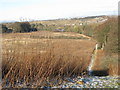
2
Newton Farm, seen from the Clyde Walkway
This stretch of the Clyde Walkway passes through overgrown fields, and closely follows the course of the river.
Image: © Lairich Rig
Taken: 10 Feb 2006
0.12 miles
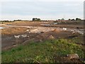
3
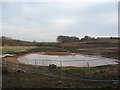
Building Site
A large area between Westburn and the River Clyde is currently being developed for housing.
Image: © Frank Smith
Taken: 27 Jan 2017
0.14 miles
4
Path from Newton Farm
In places, the path is lined by bushes; it is shown as a boundary on the map.
As the photo (taken from outside the grid square of the subject) shows, the path heads to the bank of the Clyde, then makes a sharp turn to the right (SSE); just right of centre, in the background, it meets Image
Image: © Lairich Rig
Taken: 8 Apr 2005
0.15 miles
5
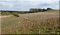
A straight section of the Clyde Walkway
The towerblocks of Glasgow can be seen in the distance.
Image: © G Laird
Taken: 31 Jan 2010
0.18 miles
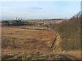
6
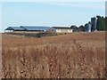
Cleared land, Newton
A large expanse of farmland which was cleared in advance of development into housing. The beginnings of the road and drainage systems can be seen in the foreground
Image: © Graham Crowe
Taken: 27 Sep 2015
0.18 miles
7
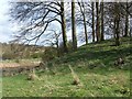
Looking back along the Clyde Walkway
This photograph was taken on a winter afternoon while following the Clyde Walkway towards Uddingston; this section of the route ascends the slopes of Honeyhill Plantation. The Walkway, as marked on maps, sticks more closely to the course of the River Clyde. However, the flat ground near the river can be extremely marshy and overgrown with reeds, and the route shown here, following the upper margin of a wooded slope, is more often followed instead. The photo shows the view seen when turning back to look along the course of the Walkway.
From the heart of Glasgow, to a disused railway viaduct that crosses the River Clyde at Carmyle, the course of the Walkway coincides with Route 75 of the National Cycle Network. However, at the southern end of the viaduct, the Walkway continues over rough fields, while the cycle route follows a different and more easily traversed route through Newton (about 1 km south from here). The two routes join up again at Blantyreferme, about a mile SE of this point.
Image: © Lairich Rig
Taken: 10 Feb 2006
0.21 miles
8

Aerial ropeway over the River Clyde
This photograph was taken from the Clyde Walkway, which, at this point, passes through some rough territory on the edges of farmland. Buildings associated with a sewage works are located on the other side of the river.
My thanks to Robert Murray, who informs me that the little white building on the far side of the ropeway is a SEPA water flow monitoring station.
Image: © Lairich Rig
Taken: 8 Apr 2005
0.22 miles
9
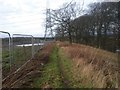
Clyde Walkway at Newton Farm
The Clyde Walkway path as it passes a sloping wooded area between the river Clyde and the fields of Newton Farm - the heras fencing denotes the eastern boundary of the construction site converting the land to housing
Image: © Graham Crowe
Taken: 24 Jan 2016
0.22 miles
10
The edge of Honeyhill Plantation
This is the north-western extremity of the plantation, which is depicted on the map. Part of the River Clyde can be seen in the left background; in this area, part of a route called the Clyde Walkway follows the near bank of the river.
See Image for a more distant view, in context; in that picture, this area can be seen in the background, just right of centre.
Image: © Lairich Rig
Taken: 8 Apr 2005
0.23 miles