IMAGES TAKEN NEAR TO
Newfield Lane, GLASGOW, G71 8JU
Introduction
This page details the photographs taken nearby to Newfield Lane, G71 8JU by members of the Geograph project.
The Geograph project started in 2005 with the aim of publishing, organising and preserving representative images for every square kilometre of Great Britain, Ireland and the Isle of Man.

There are currently over 7.5m images from over14,400 individuals and you can help contribute to the project by visiting https://www.geograph.org.uk
Image Map
Images are licensed for reuse under creativecommons.org/licenses/by-sa/2.0
Notes
- Clicking on the map will re-center to the selected point.
- The higher the marker number, the further away the image location is from the centre of the postcode.
Image Listing (5 Images Found)
Images are licensed for reuse under creativecommons.org/licenses/by-sa/2.0
Image
Details
Distance
1
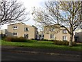
Churchill Crescent
Houses in a wooded street, Bothwell.
Image: © Richard Webb
Taken: 30 Oct 2011
0.04 miles
2
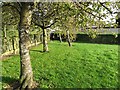
Open space, Olifard Avenue
A wooded green in a housing estate, Bothwell.
Image: © Richard Webb
Taken: 24 Oct 2011
0.09 miles
3
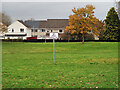
No golf practise in Bothwell
A very precise restriction notice and not the usual 'No Ball Games' notice.
Image: © wrobison
Taken: 25 Oct 2020
0.13 miles
4
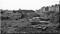
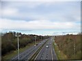
Bothwell (Caledonian Rly.) Station (remains)
View NE, towards Fallside; ex-Caledonian Rly. terminus of branch from Fallside on line from Glasgow Central via Uddingston. The branch was closed completely on 5/6/50, so it was not surprising there was little left in 1961.
Image: © Ben Brooksbank
Taken: 6 Oct 1961
0.22 miles