IMAGES TAKEN NEAR TO
Garnkirk Terrace, G69 9FX
Introduction
This page details the photographs taken nearby to Garnkirk Terrace, G69 9FX by members of the Geograph project.
The Geograph project started in 2005 with the aim of publishing, organising and preserving representative images for every square kilometre of Great Britain, Ireland and the Isle of Man.

There are currently over 7.5m images from over14,400 individuals and you can help contribute to the project by visiting https://www.geograph.org.uk
Image Map
Images are licensed for reuse under creativecommons.org/licenses/by-sa/2.0
Notes
- Clicking on the map will re-center to the selected point.
- The higher the marker number, the further away the image location is from the centre of the postcode.
Image Listing (8 Images Found)
Images are licensed for reuse under creativecommons.org/licenses/by-sa/2.0
Image
Details
Distance
1
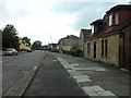
Main Street, Chryston
Looking west from near the bottom of Gartferry Road.
Image: © Stephen Sweeney
Taken: 2 Aug 2011
0.11 miles
2
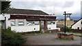
The Tavern, Chryston
A pub, closed and boarded up.
Image: © Richard Webb
Taken: 14 Oct 2011
0.15 miles
4
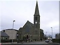
Chryston Church
http://www.glasgowkirks.org.uk/congregations/014.htm
Image: © Chris Upson
Taken: 25 Feb 2006
0.19 miles
5
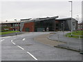
Chryston High School and Cultural Centre
On Lindsaybeg Road, Chryston High School is a non-denominational, co-educational secondary school. The school moved into this new building in August 2012.
Image: © G Laird
Taken: 1 Jan 2014
0.22 miles
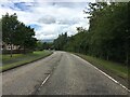
6
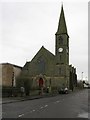
Chryston Parish Church
Church on Main Street, Chryston.
Image: © G Laird
Taken: 1 Jan 2014
0.23 miles
7
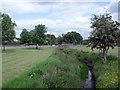
The Garnkirk Burn
As it approaches Lindsaybeg.
Image: © Robert Murray
Taken: 12 Jun 2010
0.23 miles
8
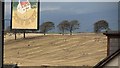
Hill of Chryston
Stubble and tyre marks beyond the sign for the now closed Tavern Image Further away, the inevitable rain moves in over the Campsie Fells.
Image: © Richard Webb
Taken: 14 Oct 2011
0.24 miles