IMAGES TAKEN NEAR TO
Urquhart Place, GLASGOW, G69 8LF
Introduction
This page details the photographs taken nearby to Urquhart Place, G69 8LF by members of the Geograph project.
The Geograph project started in 2005 with the aim of publishing, organising and preserving representative images for every square kilometre of Great Britain, Ireland and the Isle of Man.

There are currently over 7.5m images from over14,400 individuals and you can help contribute to the project by visiting https://www.geograph.org.uk
Image Map
Images are licensed for reuse under creativecommons.org/licenses/by-sa/2.0
Notes
- Clicking on the map will re-center to the selected point.
- The higher the marker number, the further away the image location is from the centre of the postcode.
Image Listing (8 Images Found)
Images are licensed for reuse under creativecommons.org/licenses/by-sa/2.0
Image
Details
Distance
1
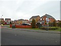
Heathfield Park
Relatively new housing development in Gartcosh.
Image: © Stephen Sweeney
Taken: 14 Feb 2012
0.05 miles
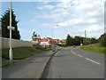
4

Mini roundabout on A752
At junction with Gartloch Road
Image: © Jim Smillie
Taken: 5 Sep 2023
0.18 miles
5
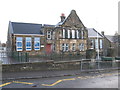
Gartcosh Primary School
On Lochend Road, Gartcosh Primary School is a non-denominational, co-educational primary school.
Image: © G Laird
Taken: 1 Jan 2014
0.21 miles
6
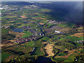
Gartcosh from the air
Bishop Loch is at the bottom of the photo, with Johnston Loch to the left of Gartcosh and the M73 motorway beyond. No trace of the steelworks remains. Viewed from a Glasgow bound flight from Luton.
Image: © Thomas Nugent
Taken: 11 May 2012
0.22 miles
7
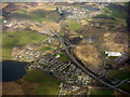
The M73 at Gartcosh from the air
Junction 2a on the M73 motorway is in the centre of the photo. The Scottish Crime Campus Image is on the right. Johnston Loch is on the left, with Garnqueen Loch at the top.
Image: © Thomas Nugent
Taken: 7 Apr 2016
0.22 miles
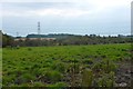
8
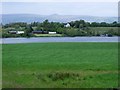
Gartcosh meadow
The water is the Johnston Loch. not really a loch as such but a Kettle pond. The ridge line is the Campsies and the peak is Meikle Binn.
Image: © Robert Murray
Taken: 13 May 2010
0.24 miles