IMAGES TAKEN NEAR TO
Avenuehead Road, GLASGOW, G69 8HN
Introduction
This page details the photographs taken nearby to Avenuehead Road, G69 8HN by members of the Geograph project.
The Geograph project started in 2005 with the aim of publishing, organising and preserving representative images for every square kilometre of Great Britain, Ireland and the Isle of Man.

There are currently over 7.5m images from over14,400 individuals and you can help contribute to the project by visiting https://www.geograph.org.uk
Image Map
Images are licensed for reuse under creativecommons.org/licenses/by-sa/2.0
Notes
- Clicking on the map will re-center to the selected point.
- The higher the marker number, the further away the image location is from the centre of the postcode.
Image Listing (3 Images Found)
Images are licensed for reuse under creativecommons.org/licenses/by-sa/2.0
Image
Details
Distance

2
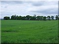
Lush field at Avenuehead
Probably being grown for winter fodder or silage.
Image: © Robert Murray
Taken: 12 Jun 2010
0.10 miles
3
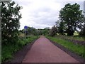
Monklands and Kirkintilloch Railway
Another stretch of the old line that has been transformed into a smart walking path as part of the Strathkelvin paths network. See also Image for info on the railway.
Image: © Robert Murray
Taken: 12 Jun 2010
0.15 miles