IMAGES TAKEN NEAR TO
Cranoch Gate, GLASGOW, G69 8FP
Introduction
This page details the photographs taken nearby to Cranoch Gate, G69 8FP by members of the Geograph project.
The Geograph project started in 2005 with the aim of publishing, organising and preserving representative images for every square kilometre of Great Britain, Ireland and the Isle of Man.

There are currently over 7.5m images from over14,400 individuals and you can help contribute to the project by visiting https://www.geograph.org.uk
Image Map
Images are licensed for reuse under creativecommons.org/licenses/by-sa/2.0
Notes
- Clicking on the map will re-center to the selected point.
- The higher the marker number, the further away the image location is from the centre of the postcode.
Image Listing (9 Images Found)
Images are licensed for reuse under creativecommons.org/licenses/by-sa/2.0
Image
Details
Distance
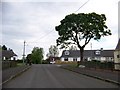
1
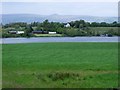
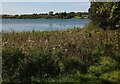
Gartcosh meadow
The water is the Johnston Loch. not really a loch as such but a Kettle pond. The ridge line is the Campsies and the peak is Meikle Binn.
Image: © Robert Murray
Taken: 13 May 2010
0.04 miles
2
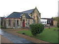
Gartcosh Parish Church
On Lochend Road, Gartcosh Parish Church was built in 1929.
Image: © G Laird
Taken: 1 Jan 2014
0.06 miles
3
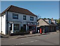
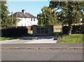
Local village shop
The pillar box suggests it may have been post office at one time
Image: © Jim Smillie
Taken: 5 Sep 2023
0.07 miles
6
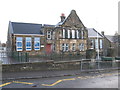
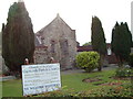
Gartcosh Primary School
On Lochend Road, Gartcosh Primary School is a non-denominational, co-educational primary school.
Image: © G Laird
Taken: 1 Jan 2014
0.14 miles
7
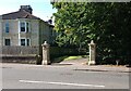
Entrance to Lochview Terrace
This terrace is shown on 1890's map
Trees now block view of loch
Image: © Jim Smillie
Taken: 5 Sep 2023
0.17 miles
9
Johnston Loch
Probably a cormorant nearer this shore
Image: © Jim Smillie
Taken: 5 Sep 2023
0.25 miles