IMAGES TAKEN NEAR TO
Tinto Grove, GLASGOW, G69 7TJ
Introduction
This page details the photographs taken nearby to Tinto Grove, G69 7TJ by members of the Geograph project.
The Geograph project started in 2005 with the aim of publishing, organising and preserving representative images for every square kilometre of Great Britain, Ireland and the Isle of Man.

There are currently over 7.5m images from over14,400 individuals and you can help contribute to the project by visiting https://www.geograph.org.uk
Image Map
Images are licensed for reuse under creativecommons.org/licenses/by-sa/2.0
Notes
- Clicking on the map will re-center to the selected point.
- The higher the marker number, the further away the image location is from the centre of the postcode.
Image Listing (14 Images Found)
Images are licensed for reuse under creativecommons.org/licenses/by-sa/2.0
Image
Details
Distance
1
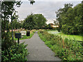
Towpath on the Monkland Canal near Bargeddie
National Cycle Route 75 follows the towpath to this point and then turns left to go through a housing estate and then Bargeddie. The canal stops a short distance further on. The rest of the canal to Port Dundas was converted to a culvert in the 1970s and most of it is now under the M8 motorway. Drumpellier Colliery Pits 3&4 were on the other side of the canal.
Image: © wrobison
Taken: 10 Sep 2022
0.06 miles
2
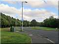
Oakridge Road, Bargeddie
The entrance road to the Drumpellier Lawns housing estate. National Cycle Route 75 goes through the estate then along the path starting at the blue sign to the Monkland Canal tow path.
Image: © wrobison
Taken: 20 Aug 2022
0.08 miles
3
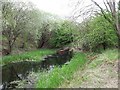
Monkland Canal and railway
The canal emerges from under the Edinburgh - Helensburgh railway. The flow is distinctive here and when the photo was taken the water was so clear that the bottom (originally 4ft.6ins) could be seen.
Image: © Robert Murray
Taken: 13 May 2010
0.12 miles
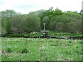
4
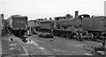
Locomotive graveyard at Bargeddie
Ex-Caledonian 'Jumbo' 2F 0-6-0 No. 57416 (built in the 1890s, withdrawn 8/61) is in the centre, with LMS 2P 4-4-0s behind and probably an LNER D11 4-4-0 on the left - a gruesome scene.
Image: © Ben Brooksbank
Taken: 5 Oct 1961
0.15 miles
5
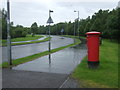
Oakridge Road, Coatbridge
Looking north showing position of Postbox No. G69 1531.
Image: © JThomas
Taken: 29 Jun 2017
0.17 miles
6
Monkland Canal, near Cuilhill
The modern western terminal of the canal. Everything west of this point was buried in two culverted pipes.
Image: © Robert Murray
Taken: 13 May 2010
0.18 miles
7
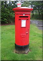
Elizabethan postbox on Oakridge Road, Coatbridge
Postbox No. G69 1531.
See Image] for context.
Image: © JThomas
Taken: 29 Jun 2017
0.19 miles
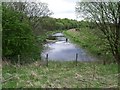
8
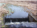
Monkland Canal Sluice, Cuilhill
Where the canal terminates as a surface waterway and disappears into two 24 inch pipes. The solar panel is a recent addition to the scene here, what for is somwehat a mytsery.
See Image for a closer look.
Image: © Robert Murray
Taken: 13 May 2010
0.19 miles
9
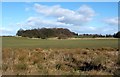
Field near Bargeddie
The picture was taken from the pavement on the northern side of Glasgow Road (as the road is called from about this point eastward), near a bus stop (I paused at the bus stop to consult my street atlas, to decide where to head next).
The area of woodland in the background is depicted on the map; beyond it, over the brow of the hill, is the Drumpellier estate.
Image: © Lairich Rig
Taken: 11 Mar 2005
0.20 miles
10
Monkland canal near Cuilhill
The Monkland canal emptying into two 24 inch pipes in which it flows underground west to Port Dundas, Glasgow.
Image: © Robert Murray
Taken: 16 Jan 2004
0.20 miles