IMAGES TAKEN NEAR TO
Little Drum Road, GLASGOW, G68 9LH
Introduction
This page details the photographs taken nearby to Little Drum Road, G68 9LH by members of the Geograph project.
The Geograph project started in 2005 with the aim of publishing, organising and preserving representative images for every square kilometre of Great Britain, Ireland and the Isle of Man.

There are currently over 7.5m images from over14,400 individuals and you can help contribute to the project by visiting https://www.geograph.org.uk
Image Map
Images are licensed for reuse under creativecommons.org/licenses/by-sa/2.0
Notes
- Clicking on the map will re-center to the selected point.
- The higher the marker number, the further away the image location is from the centre of the postcode.
Image Listing (7 Images Found)
Images are licensed for reuse under creativecommons.org/licenses/by-sa/2.0
Image
Details
Distance

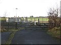
2

Old alignment, Mollins Road
Waste land and a dumper magnet between two parallel grown out hedges. This is the old road left when a wider version was built to serve the nearby industrial estates.
Image: © Richard Webb
Taken: 4 Mar 2011
0.16 miles
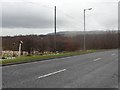
3

Mollins Road
Winding road northwest of Cumbernauld, between Twechar and the industrial parks.
Image: © Stephen Sweeney
Taken: 20 Dec 2011
0.16 miles
6
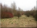
Woodland, Drumgrew
A young woodland which fills in the undeveloped corners of an industrial zone on the southern edge of Cumbernauld.
Image: © Richard Webb
Taken: 4 Mar 2011
0.20 miles