IMAGES TAKEN NEAR TO
Napier Court, GLASGOW, G68 0LG
Introduction
This page details the photographs taken nearby to Napier Court, G68 0LG by members of the Geograph project.
The Geograph project started in 2005 with the aim of publishing, organising and preserving representative images for every square kilometre of Great Britain, Ireland and the Isle of Man.

There are currently over 7.5m images from over14,400 individuals and you can help contribute to the project by visiting https://www.geograph.org.uk
Image Map
Images are licensed for reuse under creativecommons.org/licenses/by-sa/2.0
Notes
- Clicking on the map will re-center to the selected point.
- The higher the marker number, the further away the image location is from the centre of the postcode.
Image Listing (10 Images Found)
Images are licensed for reuse under creativecommons.org/licenses/by-sa/2.0
Image
Details
Distance
1
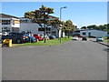
Wardpark Industrial Estate
Industrial units on the northern outskirts of Cumbernauld.
Image: © M J Richardson
Taken: 27 Jun 2019
0.07 miles
2

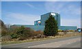
New Office Space
Napier Place, Wardpark
Image: © Texas Radio and The Big Beat
Taken: 10 Apr 2010
0.08 miles
3

Wardpark Industrial Estate
Industrial/business units on the northern outskirts of Cumbernauld.
Image: © M J Richardson
Taken: 27 Jun 2019
0.12 miles
4
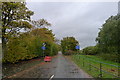
Wyndford Road leaving Wardpark Industrial Estate
The road, which runs north towards the Forth and Clyde Canal, appears to have been permanently closed https://www.cumbernauld-news.co.uk/news/transport/council-finally-admits-wyndford-road-will-never-reopen-1-4738304
Image: © Tim Heaton
Taken: 9 Oct 2018
0.13 miles
6
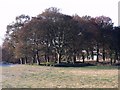
Cumbernauld, Antonine Wall
This stand of trees marks a break in the visible remains of the Antonine Wall at Wardpark near the village of Castlecary.
Image: © Robert Murray
Taken: 9 Nov 2009
0.17 miles
7
Isola Building (unoccupied)
Closed around 2005.
Image: © Texas Radio and The Big Beat
Taken: 10 Apr 2010
0.18 miles

9

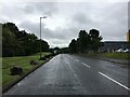
Wyndford Road, Wardpark
Now closed to vehicular traffic, this section of Wyndford Road passes through a section of the Antonine Wall, a Roman defensive structure built in the 2nd century AD.
Image: © Euan Nelson
Taken: 1 Oct 2016
0.19 miles
10
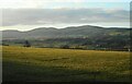
Looking towards the Campsie Fells
The Glasgow to Edinburgh railway line cuts across the view from left to right.
Image: © Richard Sutcliffe
Taken: 1 Mar 2022
0.23 miles