IMAGES TAKEN NEAR TO
Gailes Road, GLASGOW, G68 0JJ
Introduction
This page details the photographs taken nearby to Gailes Road, G68 0JJ by members of the Geograph project.
The Geograph project started in 2005 with the aim of publishing, organising and preserving representative images for every square kilometre of Great Britain, Ireland and the Isle of Man.

There are currently over 7.5m images from over14,400 individuals and you can help contribute to the project by visiting https://www.geograph.org.uk
Image Map
Images are licensed for reuse under creativecommons.org/licenses/by-sa/2.0
Notes
- Clicking on the map will re-center to the selected point.
- The higher the marker number, the further away the image location is from the centre of the postcode.
Image Listing (12 Images Found)
Images are licensed for reuse under creativecommons.org/licenses/by-sa/2.0
Image
Details
Distance
1
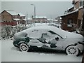
Once a year weather in Cumbernauld
Stay away from the office weather! Roads impassable.
Image: © Greg Morss
Taken: 31 Jan 2004
0.16 miles
2
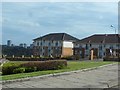
Portland Road, Carrickstone
And a distant view across Cumbernauld.
Image: © Stephen Sweeney
Taken: 16 Apr 2014
0.18 miles
3
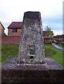
Carrickstone Trig
Situated just a few steps away from the Carrick Stone in this high spot of Cumbernauld.
Image: © Robert Murray
Taken: 9 Jun 2007
0.19 miles
5
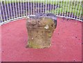
The Carrick Stone
Allegedly a Roman altar. It certainly looks as if it could have been part of a bigger object. The long since demolished Carrickstone farm and the present surrounding suburb is named after the stone.
Image: © Robert Murray
Taken: 9 Jun 2007
0.22 miles
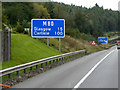
6
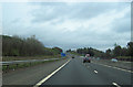
M80 east sign for Old Inns services at Junction 6
Road is in a slight cutting here as shown on map
Image: © John Firth
Taken: 13 May 2012
0.22 miles
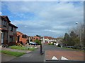
10
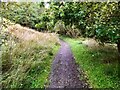
Westerwood, Path between trees near Cumbernauld Golf Course
Image: © David Dixon
Taken: 24 Sep 2021
0.24 miles