IMAGES TAKEN NEAR TO
Tintock Place, GLASGOW, G68 0AD
Introduction
This page details the photographs taken nearby to Tintock Place, G68 0AD by members of the Geograph project.
The Geograph project started in 2005 with the aim of publishing, organising and preserving representative images for every square kilometre of Great Britain, Ireland and the Isle of Man.

There are currently over 7.5m images from over14,400 individuals and you can help contribute to the project by visiting https://www.geograph.org.uk
Image Map
Images are licensed for reuse under creativecommons.org/licenses/by-sa/2.0
Notes
- Clicking on the map will re-center to the selected point.
- The higher the marker number, the further away the image location is from the centre of the postcode.
Image Listing (27 Images Found)
Images are licensed for reuse under creativecommons.org/licenses/by-sa/2.0
Image
Details
Distance
1
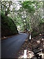
Glen Road at Dullatur
Before the building of the railway in 1844 this road went directly to East Dullatur Farm but was re-aligned. On the western (left in this photo) side of this road are the workings of three old quarries and it may be that the route itself is the result of that quarrying. Further down the glen there were two limekilns.
The burn flowing down the right hand side of the road is the Chantyclear burn. This burn flows to Dullatur Bog where it joins up with drainage ditches and eventually flows under the Forth & Clyde Canal to join another drainage ditch called Kelvin Water.
Image: © Robert Murray
Taken: 6 Oct 2009
0.07 miles
2
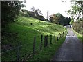
A different looking Antonine Wall
Overlooking East Dullatur Farm, more like a terraced fortified line than a wall.
Image: © Robert Murray
Taken: 6 Oct 2009
0.13 miles
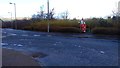
3
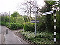
To Cumbernauld
This signpost can be found in Dullatur
Image: © Stevie Spiers
Taken: 17 May 2009
0.13 miles
4
Roman Soldier Statue
This statue can be found near the entrance to Dullatur Village, Cumbernauld
Image: © Stevie Spiers
Taken: 17 Sep 2007
0.13 miles
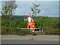
5
Roman soldier guards Dullatur
Dullatur is a village within the vicinity of Cumbernauld, Scotland. The route of the Antonine Wall passed right over the site of Dullatur, and a Roman camp was actually sited there as well.
Image: © Stevie Spiers
Taken: 17 Sep 2007
0.14 miles
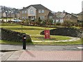
6
Roman soldier, Dullatur
Two temporary Roman camps once occupied the site of the modern village of Dullatur.
Image: © Euan Nelson
Taken: 25 Feb 2017
0.15 miles
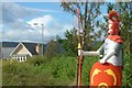
7
Roman themed feature, Dullatur.
Westerton Rd Dullatur with its Roman themed feature. The area has a mass of Roman history being about the midway point on the Antonine Wall.
Image: © Jim Bain
Taken: 26 Feb 2006
0.17 miles
8
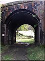
Railway bridge over Parish Road
The Network Rail sign names this as Bridge No. EGM1/094 and the track as 'Parish Road' - a common enough name in Scotland but use of is generally long lapsed. The bridge has had an internal steel frame fitted to reinforce the structure.
Image: © Robert Murray
Taken: 6 Oct 2009
0.17 miles
9
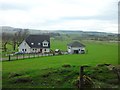
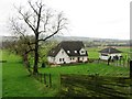
Farmhouse near Dullatur
To the north of the village, on the public path to the Antonine Wall.
Image: © Stephen Sweeney
Taken: 16 Apr 2014
0.17 miles