IMAGES TAKEN NEAR TO
Cumbernauld, GLASGOW, G67 4HQ
Introduction
This page details the photographs taken nearby to G67 4HQ by members of the Geograph project.
The Geograph project started in 2005 with the aim of publishing, organising and preserving representative images for every square kilometre of Great Britain, Ireland and the Isle of Man.

There are currently over 7.5m images from over14,400 individuals and you can help contribute to the project by visiting https://www.geograph.org.uk
Image Map
Images are licensed for reuse under creativecommons.org/licenses/by-sa/2.0
Notes
- Clicking on the map will re-center to the selected point.
- The higher the marker number, the further away the image location is from the centre of the postcode.
Image Listing (4 Images Found)
Images are licensed for reuse under creativecommons.org/licenses/by-sa/2.0
Image
Details
Distance
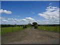
1
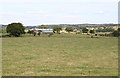
Muirend
The buildings at Muirend Farm straddle the crossing of two gridlines, but all the foreground is in this square.
Image: © Anne Burgess
Taken: 25 Aug 2015
0.01 miles
3
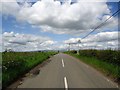
Mollinsburn Road
The crest of the hill is 108m ASL.
Image: © Robert Murray
Taken: 28 Jun 2011
0.20 miles
4
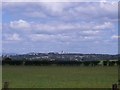
Annathill, pasture
View to north-east with the town of Cumbernauld in the distance.
Image: © Robert Murray
Taken: 28 Jun 2011
0.23 miles