IMAGES TAKEN NEAR TO
Badenheath Terrace, GLASGOW, G67 4HL
Introduction
This page details the photographs taken nearby to Badenheath Terrace, G67 4HL by members of the Geograph project.
The Geograph project started in 2005 with the aim of publishing, organising and preserving representative images for every square kilometre of Great Britain, Ireland and the Isle of Man.

There are currently over 7.5m images from over14,400 individuals and you can help contribute to the project by visiting https://www.geograph.org.uk
Image Map
Images are licensed for reuse under creativecommons.org/licenses/by-sa/2.0
Notes
- Clicking on the map will re-center to the selected point.
- The higher the marker number, the further away the image location is from the centre of the postcode.
Image Listing (32 Images Found)
Images are licensed for reuse under creativecommons.org/licenses/by-sa/2.0
Image
Details
Distance
1
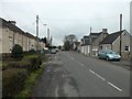
Entering Mollinsburn from the east
On Airdrie Road.
Image: © Stephen Sweeney
Taken: 10 Jan 2012
0.01 miles
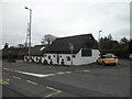
2

Cottage Industry, Mollinsburn
Three separate small businesses operate out of this cottage row.
Image: © Texas Radio and The Big Beat
Taken: 10 Apr 2010
0.04 miles
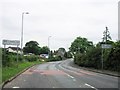
3
Finishing Touches
Home furnishings shop in Mollinsburn.
Image: © Stephen Sweeney
Taken: 10 Jan 2012
0.06 miles
5
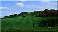
Badenheath Park
The ridge forming the southern part of this farm.
Image: © Robert Murray
Taken: 25 Apr 2011
0.13 miles
6
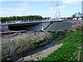
Badenheath Park, Mollins Burn
The Mollins flowing along its new deviation towards its confluence with Luggie Water.
Image: © Robert Murray
Taken: 25 Apr 2011
0.14 miles
7
Power lines, Mollinsburn
View with my back to the motorway construction works at the entrance of Badenheath Park.
Image: © Richard Webb
Taken: 4 Mar 2011
0.14 miles
8
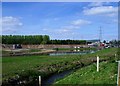
Mollinsburn, suds ponds
Newly created to take the surface water from the new M80 before discharging it into Luggie Water. The new Mollins Burn deviation is in the foreground.
Image: © Robert Murray
Taken: 25 Apr 2011
0.15 miles
9
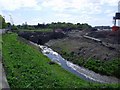
Badenheath Park, Mollins Burn
The diverted Mollins which now empties into Luggie Water south of the new alignment of the M80 whereas beforehand it did so north of the A80.
Image: © Robert Murray
Taken: 25 Apr 2011
0.16 miles
10
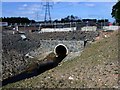
Badenheath Park, Mollins Burn
The burn goes through this culvert which presumably will carry an access road to the big suds ponds.
Image: © Robert Murray
Taken: 25 Apr 2011
0.16 miles