IMAGES TAKEN NEAR TO
Kirkview Court, GLASGOW, G67 4EJ
Introduction
This page details the photographs taken nearby to Kirkview Court, G67 4EJ by members of the Geograph project.
The Geograph project started in 2005 with the aim of publishing, organising and preserving representative images for every square kilometre of Great Britain, Ireland and the Isle of Man.

There are currently over 7.5m images from over14,400 individuals and you can help contribute to the project by visiting https://www.geograph.org.uk
Image Map
Images are licensed for reuse under creativecommons.org/licenses/by-sa/2.0
Notes
- Clicking on the map will re-center to the selected point.
- The higher the marker number, the further away the image location is from the centre of the postcode.
Image Listing (50 Images Found)
Images are licensed for reuse under creativecommons.org/licenses/by-sa/2.0
Image
Details
Distance
1
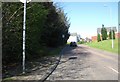
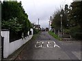
Condorrat in the town Of Cumbernauld
Heading in to the housing estates.
Image: © James Denham
Taken: 18 Apr 2009
0.04 miles
2
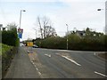
Main Road, Condorrat
The western roundabout with the ring road to right.
Image: © Robert Murray
Taken: 28 Apr 2010
0.07 miles
3
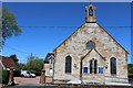
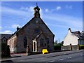
Condorrat Parish Church
Opened for worship in 1875
Image: © Leslie Barrie
Taken: 23 May 2015
0.08 miles
4
Condorrat Parish Church
The construction of the church at Condorrat was completed in 1875, with money being raised by the local people, the majority of whom were weavers, miners and quarrymen.
Image: © Euan Nelson
Taken: 18 Feb 2018
0.09 miles
6
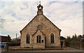
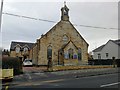
Condorrat Parish Church
Image: © Texas Radio and The Big Beat
Taken: 8 Mar 2010
0.11 miles
7
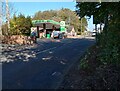
Petrol Station Condorrat
Interesting to compare prices over the years: Petrol 155.9p
Image: © Jim Smillie
Taken: 14 Oct 2023
0.11 miles
8
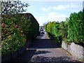
Condorrat, lane
Joins Main Road and Rosehill Drive.
Image: © Robert Murray
Taken: 25 Apr 2011
0.12 miles
9
Rosehill and Red Bridge
A pedestrian thoroughfare between Condorrat and Westfield, Rosehill Cottage is on the left and the 'rid brig' on the right.
Image: © Robert Murray
Taken: 10 Oct 2009
0.16 miles
10
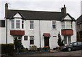
John Baird's House
At the end of the 18th century, the government would not listen to the people especially the returning soldiers, so began the industrial revolution. Unemployment was gradually taking hold and the soldiers who had fought a hard war were not prepared to sit back in squalor devoid of livelihood. This resulted in the radical reform movement, which eventually took hold across the country. The government on the other hand saw the protest of these men, as treason. A group of dissatisfied workers marched from Glasgow to the village of Condorrat situated south of Kilsyth and west of Cumbernauld Village. One of those radicals who was determined to stand up and be counted in a fight against a government which had alienated its people, was John Baird. The result was armed conflict.
The ringleaders were John Baird and Andrew Hardie.
Both these men were tried and executed for treason.
Quoted from William Chalmer's website on Condorrat and Castlecary http://myweb.tiscali.co.uk/kilsyth/condorrat-&-castlecary.htm
Image: © Texas Radio and The Big Beat
Taken: 8 Mar 2010
0.16 miles