IMAGES TAKEN NEAR TO
Stirling Road, GLASGOW, G67 4AB
Introduction
This page details the photographs taken nearby to Stirling Road, G67 4AB by members of the Geograph project.
The Geograph project started in 2005 with the aim of publishing, organising and preserving representative images for every square kilometre of Great Britain, Ireland and the Isle of Man.

There are currently over 7.5m images from over14,400 individuals and you can help contribute to the project by visiting https://www.geograph.org.uk
Image Map
Images are licensed for reuse under creativecommons.org/licenses/by-sa/2.0
Notes
- Clicking on the map will re-center to the selected point.
- The higher the marker number, the further away the image location is from the centre of the postcode.
Image Listing (23 Images Found)
Images are licensed for reuse under creativecommons.org/licenses/by-sa/2.0
Image
Details
Distance
1
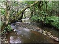
The Luggie Water
Flowing through the ravine north of the village.
Image: © Robert Murray
Taken: 12 Oct 2009
0.02 miles
2
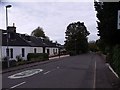
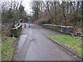
Stirling Road, Luggiebank
There is only one road and a pillar box in this delightful village.
Image: © Robert Murray
Taken: 12 Oct 2009
0.02 miles
3
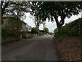
Stirling Road Luggiebank
Now blocked off just behind this viewpoint
Image: © Jim Smillie
Taken: 30 Sep 2023
0.05 miles
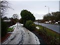
4
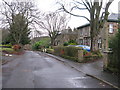
Stirling Road, Luggiebank
The quiet village of Luggiebank has been bypassed since the mid 1960s.
Image: © G Laird
Taken: 5 Jan 2014
0.05 miles
5
Old Lane, Luggiebank
This lane used to run from Luggiebank to Clayslope and Mid Blairlinn farms.
The farms are now gone (demolished when Blairlinn Ind Est was built)
and the lane is now an access road to many of the village's newer houses.
Image: © Texas Radio and The Big Beat
Taken: 16 Jan 2010
0.08 miles
6
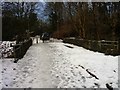
The Auld Bridge, Luggiebank
The bridge has been closed to traffic for years.
Image: © Texas Radio and The Big Beat
Taken: 16 Jan 2010
0.10 miles
7
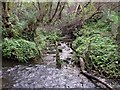
Luggiebank, confluence
An unnamed burn from the south joins the Luggie Water just east of the village. What the old fence across the stream is supposed to do is anybody's guess.
Image: © Robert Murray
Taken: 12 Oct 2009
0.10 miles
8
The Auld Bridge, Luggiebank
Image: © Texas Radio and The Big Beat
Taken: 16 Jan 2010
0.11 miles
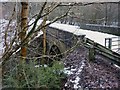
9
Luggie Bridge
It is difficult to believe now that until the mid 1960s this bridge over the Luggie Water carried the main trunk road, the A73, which was very busy even in the 1960s because it was then the main connecting road between the A74 at Abington and the A80 at Cumbernauld.
It was first bypassed by another road into an expanding Cumbernauld. By about 1970, the A73 moved further west joining the A80 at the Auchenkilns roundabout.
Image: © G Laird
Taken: 5 Jan 2014
0.11 miles
10
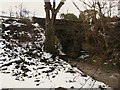
The Auld Bridge, Luggiebank
The old road bridge over the Luggie was closed to traffic many years ago.
The bridge now only carries pedestrians.
Image: © Texas Radio and The Big Beat
Taken: 16 Jan 2010
0.11 miles