IMAGES TAKEN NEAR TO
Cumbernauld, GLASGOW, G67 3JW
Introduction
This page details the photographs taken nearby to G67 3JW by members of the Geograph project.
The Geograph project started in 2005 with the aim of publishing, organising and preserving representative images for every square kilometre of Great Britain, Ireland and the Isle of Man.

There are currently over 7.5m images from over14,400 individuals and you can help contribute to the project by visiting https://www.geograph.org.uk
Image Map (Loading...)


Getting Data...Please wait
Leaflet Map data © OpenStreetMap
Images are licensed for reuse under creativecommons.org/licenses/by-sa/2.0
Notes
- Clicking on the map will re-center to the selected point.
- The higher the marker number, the further away the image location is from the centre of the postcode.
Image Listing (6 Images Found)
Images are licensed for reuse under creativecommons.org/licenses/by-sa/2.0
Image
Details
Distance
1
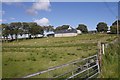
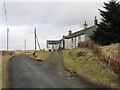
Arns
Surviving open land in a heavily forested area.
Image: © Richard Webb
Taken: 25 Sep 2016
0.09 miles
2
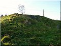
Old Limekiln (near Arns Farm)
About 50m to the east of Arns Farm is this old limekiln.
Image: © Texas Radio and The Big Beat
Taken: 17 Oct 2009
0.10 miles
3
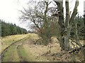
Track to Garbet Farm
The track to the ruined Garbet Farm passes one of many
"high seats" in the area.
See www.geograph.org.uk/photo/1685148 for explanation.
Image: © Texas Radio and The Big Beat
Taken: 15 Mar 2010
0.19 miles
4
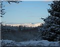
A Gap In The Trees
On the track to Garbet Farm, a gap in the trees reveals this splendid
winter view of Meikle Bin, some eight or so miles away.
Image: © Texas Radio and The Big Beat
Taken: 8 Jan 2011
0.21 miles
6
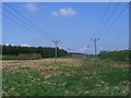
Crowbank, transmission lines
Heading off towards Denny.
Image: © Robert Murray
Taken: 2 May 2011
0.23 miles