IMAGES TAKEN NEAR TO
South Wardpark Place, GLASGOW, G67 3HX
Introduction
This page details the photographs taken nearby to South Wardpark Place, G67 3HX by members of the Geograph project.
The Geograph project started in 2005 with the aim of publishing, organising and preserving representative images for every square kilometre of Great Britain, Ireland and the Isle of Man.

There are currently over 7.5m images from over14,400 individuals and you can help contribute to the project by visiting https://www.geograph.org.uk
Image Map
Images are licensed for reuse under creativecommons.org/licenses/by-sa/2.0
Notes
- Clicking on the map will re-center to the selected point.
- The higher the marker number, the further away the image location is from the centre of the postcode.
Image Listing (29 Images Found)
Images are licensed for reuse under creativecommons.org/licenses/by-sa/2.0
Image
Details
Distance
1
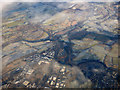
Cumbernauld from the air
The M80 motorway can be seen heading north to Stirling via Castlecary, where the Forth & Clyde canal and the main Glasgow to Edinburgh railway both cross (one under, one over). Banknock and Bonnybridge are also visible.
Image: © Thomas Nugent
Taken: 11 Dec 2017
0.04 miles
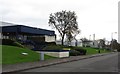
2
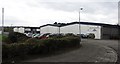
Wardpark South Industrial Estate
Junction of Wardpark Road and Wardpark Place in the industrial estate. Wardpark was a farm before Cumbernauld new town.
Image: © Richard Webb
Taken: 14 Oct 2011
0.05 miles
3
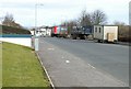
Wardpark industrial estate, Cumbernauld.
This area just off the A80 is full of distribution centres and industrial buildings all with easy reach of much of Scotland's population. The truck is heading for the Co-Op distribution centre just behind my position.
Image: © Jim Bain
Taken: 26 Feb 2006
0.10 miles
4
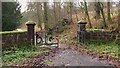
Old Gates to Cumbernauld House
Old gates to Cumbernauld house just off Broom Road.
Image: © Texas Radio and The Big Beat
Taken: 28 Nov 2009
0.13 miles
5
Wardpark South Industrial Estate
Wardpark is an industrial estate built on either side of the A80, now the M80 in the north of Cumbernauld. There was once a farm here called Wardpark.
Image: © Richard Webb
Taken: 14 Oct 2011
0.13 miles
6
Crow Wood, Cumbernauld Glen Nature Reserve
Image: © Euan Nelson
Taken: 17 Jan 2016
0.15 miles
7
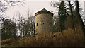
Dovecote near Cumbernauld House
"The doocot, a B listed building where once doves were reared for the table of local lairds the Fleming family. The restoration was undertaken by the Scottish Lime Centre Trust masonry training squad, who replaced modern cement with material closer to the kind used in the 17th century, the dovecot should remain in prime condition for decades to come."
(Info from Cumbernauld House Park website).
Image: © Texas Radio and The Big Beat
Taken: 28 Nov 2009
0.16 miles
8
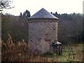
Dovecote
Viewed from the rear. Both front and rear entrances are bricked up.
Image: © Texas Radio and The Big Beat
Taken: 28 Nov 2009
0.16 miles
9
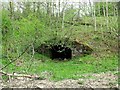
Old tunnel, Cumbernauld Glen
Situated about 25m away from the tunnel taking the Red Burn under the big embankment and of similar build is this rather forlorn looking and smaller tunnel. With the absence of any history of mineral railways or tramways in the glen it might be that this was built as a passage under the embankment for pedestrians and horse traffic associated with the estate.
Image: © Robert Murray
Taken: 11 May 2010
0.17 miles
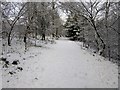
10
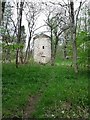
Path to the Doocot, Cumbernauld Glen
Or dovecote in english. Splendid description at Image
Image: © Robert Murray
Taken: 11 May 2010
0.17 miles