IMAGES TAKEN NEAR TO
Spruce Road, GLASGOW, G67 3DS
Introduction
This page details the photographs taken nearby to Spruce Road, G67 3DS by members of the Geograph project.
The Geograph project started in 2005 with the aim of publishing, organising and preserving representative images for every square kilometre of Great Britain, Ireland and the Isle of Man.

There are currently over 7.5m images from over14,400 individuals and you can help contribute to the project by visiting https://www.geograph.org.uk
Image Map
Images are licensed for reuse under creativecommons.org/licenses/by-sa/2.0
Notes
- Clicking on the map will re-center to the selected point.
- The higher the marker number, the further away the image location is from the centre of the postcode.
Image Listing (25 Images Found)
Images are licensed for reuse under creativecommons.org/licenses/by-sa/2.0
Image
Details
Distance
1
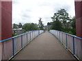
Abronhill footbridge
Footbridge over Blackthorn Road.
Image: © Ross Watson
Taken: 5 Aug 2013
0.09 miles
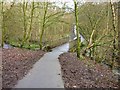
2
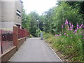
Ochil View
Pathway by-passing flat accommodation, leading to underpass.
Image: © Ross Watson
Taken: 5 Aug 2013
0.11 miles
3
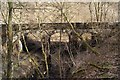
Vault Glen Railway Viaduct
Carries the Cumbernauld - Falkirk line over the Red Burn.
Image: © Texas Radio and The Big Beat
Taken: 20 Mar 2010
0.11 miles
5
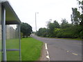
Blackthorn Road Bus Stop
A bus stop on the main road of Abronhill.
Image: © Ross Watson
Taken: 5 Aug 2013
0.13 miles
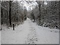
6
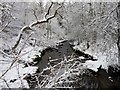
Red Burn, Cumbernauld Glen Nature Reserve
Image: © Euan Nelson
Taken: 17 Jan 2016
0.13 miles
7
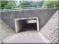
Abronhill Underpass
Underpass at Blackthorn Road.
Image: © Ross Watson
Taken: 5 Aug 2013
0.14 miles
8
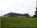
Struthers Pentecostal Church
A pentecostal church near Larch Road, Abronhill.
Image: © Ross Watson
Taken: 5 Aug 2013
0.16 miles
9

Abronhill Parish Church Tower
A tower near the parish church.
Image: © Ross Watson
Taken: 5 Aug 2013
0.16 miles
10
Bridge in Vault Glen
Bridge over Glencryan Burn in Vault Glen.
Modern maps show this as "Red Burn" but according to older maps it
doesn't meet up with Red Burn till a little further downstream.
Image: © Texas Radio and The Big Beat
Taken: 28 Nov 2009
0.17 miles