IMAGES TAKEN NEAR TO
Rowan Road, GLASGOW, G67 3BU
Introduction
This page details the photographs taken nearby to Rowan Road, G67 3BU by members of the Geograph project.
The Geograph project started in 2005 with the aim of publishing, organising and preserving representative images for every square kilometre of Great Britain, Ireland and the Isle of Man.

There are currently over 7.5m images from over14,400 individuals and you can help contribute to the project by visiting https://www.geograph.org.uk
Image Map
Images are licensed for reuse under creativecommons.org/licenses/by-sa/2.0
Notes
- Clicking on the map will re-center to the selected point.
- The higher the marker number, the further away the image location is from the centre of the postcode.
Image Listing (6 Images Found)
Images are licensed for reuse under creativecommons.org/licenses/by-sa/2.0
Image
Details
Distance
2
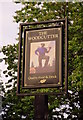
Struthers Pentecostal Church
A pentecostal church near Larch Road, Abronhill.
Image: © Ross Watson
Taken: 5 Aug 2013
0.18 miles
3
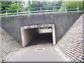
Abronhill Underpass
Underpass at Blackthorn Road.
Image: © Ross Watson
Taken: 5 Aug 2013
0.18 miles
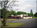
5
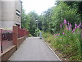
Ochil View
Pathway by-passing flat accommodation, leading to underpass.
Image: © Ross Watson
Taken: 5 Aug 2013
0.21 miles
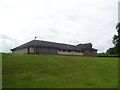
6
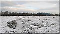
Abronhill Peat Bog
Between Abronhill High School and Blackthorn Road there is a large area
of peat bog. Aerial pictures show long, parallel lines which would indicate
that the peat has been cultivated sometime relatively recently.
Whether this was done before Abronhill was built or after I do not know
although I would assume it would have been before.
Abronhill High School in the distance.
Image: © Texas Radio and The Big Beat
Taken: 19 Dec 2009
0.22 miles