IMAGES TAKEN NEAR TO
Stonylee Road, GLASGOW, G67 2LX
Introduction
This page details the photographs taken nearby to Stonylee Road, G67 2LX by members of the Geograph project.
The Geograph project started in 2005 with the aim of publishing, organising and preserving representative images for every square kilometre of Great Britain, Ireland and the Isle of Man.

There are currently over 7.5m images from over14,400 individuals and you can help contribute to the project by visiting https://www.geograph.org.uk
Image Map
Images are licensed for reuse under creativecommons.org/licenses/by-sa/2.0
Notes
- Clicking on the map will re-center to the selected point.
- The higher the marker number, the further away the image location is from the centre of the postcode.
Image Listing (56 Images Found)
Images are licensed for reuse under creativecommons.org/licenses/by-sa/2.0
Image
Details
Distance
1

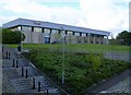
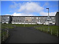
Carbrain Housing
A good example of the modernist style housing at Carbrain.
Image: © David Bremner
Taken: 16 May 2023
0.14 miles
3
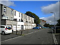
Southern part of Kilbowie Road, Cumbernauld
Image: © Richard Vince
Taken: 12 Sep 2022
0.16 miles
4
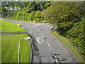
East end of Kilbowie Road, Cumbernauld
Seen from a footbridge just north of its junction with South Carbrain Road (behind the photographer). Kilbowie Road continues to the left, with Greenrigg Road heading off on the right.
Image: © Richard Vince
Taken: 12 Sep 2022
0.16 miles
5
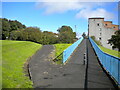
Footpaths off Kilbowie Road, Cumbernauld
The path on the right climbs to a footbridge across the east end of Kilbowie Road, then continues parallel to South Carbrain Road (out of frame on the right, on the other side of the flats). The path on the left descends to meet Kilbowie Road opposite its junction with Greenrigg Road. Behind the photographer, the path joins the southern branch of Kilbowie Road.
Image: © Richard Vince
Taken: 12 Sep 2022
0.17 miles
6
Footpath north of South Carbrain Road, Cumbernauld
Immediately north of Image, this path splits into three. The first left leads up to the pavement along the north side of South Carbrain Road; it is signposted as providing step free access to platform 1 of Cumbernauld railway station, which involves a lengthy journey to the footbridge at the west end of the station. The other two bits of the path lead to various bits of Kilbowie Road, onto the southern section of which the housing fronts.
Image: © Richard Vince
Taken: 12 Sep 2022
0.17 miles
7
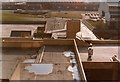
Cumbernauld Town Centre
Taken in 1981, most of what you can see in the foreground has been demolished and redeveloped. The building on the right is Cumbernauld College, still there to this day. North Carbrain Road is at the top of the picture.
Image: © Robert Struthers
Taken: Unknown
0.17 miles
8

Footpath to Greenrigg Road, Cumbernauld
Off an elevated path that parallels South Carbrain Road.
Image: © Richard Vince
Taken: 12 Sep 2022
0.17 miles
10
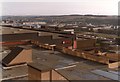
Cumbernauld Town Centre
Much of what can be seen here, taken in 1981, is now gone. Woolco was a massive supermarket, touted as Scotland's first "hypermarket". The building just visible behind Woolco is part of the council offices, and are still there today. Behind that are the houses of Carbrain, and in the distance Palacerigg and Fannyside Moor.
Image: © Robert Struthers
Taken: Unknown
0.18 miles