IMAGES TAKEN NEAR TO
Tarbolton Road, GLASGOW, G67 2AF
Introduction
This page details the photographs taken nearby to Tarbolton Road, G67 2AF by members of the Geograph project.
The Geograph project started in 2005 with the aim of publishing, organising and preserving representative images for every square kilometre of Great Britain, Ireland and the Isle of Man.

There are currently over 7.5m images from over14,400 individuals and you can help contribute to the project by visiting https://www.geograph.org.uk
Image Map
Images are licensed for reuse under creativecommons.org/licenses/by-sa/2.0
Notes
- Clicking on the map will re-center to the selected point.
- The higher the marker number, the further away the image location is from the centre of the postcode.
Image Listing (27 Images Found)
Images are licensed for reuse under creativecommons.org/licenses/by-sa/2.0
Image
Details
Distance
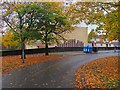
1
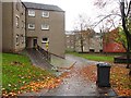
Flats off Tarbolton Road
Kildrum, Cumbernauld
Image: © Richard Webb
Taken: 18 Oct 2010
0.05 miles
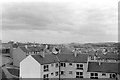
2
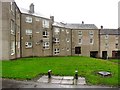
Flats, Kildrum
Remains of a bench in front of a group of Cumbernauld flats.
Image: © Richard Webb
Taken: 18 Oct 2010
0.05 miles
3
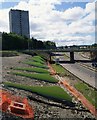
Cumbernauld's Light Sculpture
Part of the Cumbernauld Positive Image Campaign.
"The special effects are achieved by fins positioned on the embankments
of at A8011 - the approach road to the town centre. The intention is to
emulate the feeling of driving alongside a giant wave." Cumbernauld News.
See also www.geograph.org.uk/photo/2039476
Image: © Texas Radio and The Big Beat
Taken: 29 Aug 2010
0.07 miles
4
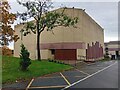
Sacred Heart RC Church
The church by the celebrated Scottish architects Isi Metzstein and Andy MacMillan is in the Kildrum area of the New Town.
Image: © David Bremner
Taken: 10 Oct 2023
0.08 miles
5
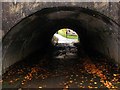
Underpass, Cumbernauld
Path under North Carbrain Road.
Image: © Richard Webb
Taken: 18 Oct 2010
0.09 miles
6
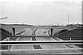
Braehead Roundabout over Central Way, Cumbernauld ? 1964
Central Way (A8011) is the principal spine road of the new town. Since this view, a tower block arose on the left hand side https://www.geograph.org.uk/photo/2039507 , but remarkably this has since been demolished to provide a similar skyline in 2019 (bar some tree growth) https://goo.gl/maps/xt2zTZH2ZMngLhri9
Image: © Alan Murray-Rust
Taken: Unknown
0.09 miles
8
Cumbernauld housing ? 1964
Part of the Kyle Road development in the Kildrum area.
The view must have been taken from the roof of the Sacred Heart church, which would have been under construction at the time. The visit to Cumbernauld was part of an architectural study tour when I was a student.
Image: © Alan Murray-Rust
Taken: Unknown
0.10 miles
9
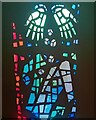
Sacred Heart RC Church
Stained glass by Sadie McLellan.
Image: © David Bremner
Taken: 10 Oct 2023
0.11 miles
10
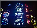
Sacred Heart RC Church
Stained glass by Sadie McLellan.
Image: © David Bremner
Taken: 10 Oct 2023
0.11 miles