IMAGES TAKEN NEAR TO
Crow Road, GLASGOW, G66 7NU
Introduction
This page details the photographs taken nearby to Crow Road, G66 7NU by members of the Geograph project.
The Geograph project started in 2005 with the aim of publishing, organising and preserving representative images for every square kilometre of Great Britain, Ireland and the Isle of Man.

There are currently over 7.5m images from over14,400 individuals and you can help contribute to the project by visiting https://www.geograph.org.uk
Image Map
Images are licensed for reuse under creativecommons.org/licenses/by-sa/2.0
Notes
- Clicking on the map will re-center to the selected point.
- The higher the marker number, the further away the image location is from the centre of the postcode.
Image Listing (6 Images Found)
Images are licensed for reuse under creativecommons.org/licenses/by-sa/2.0
Image
Details
Distance
1
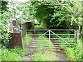
Lane, Campsie-Lennoxtown golf course
Leading to the Crow Road.
Image: © Robert Murray
Taken: 1 Aug 2010
0.03 miles
2
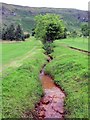
The Burnel Rannie
The water of this burn is clear coming off the hill and only discolours as it passes by the old coal and lime workings just north of the golf course.
Image: © Robert Murray
Taken: 1 Aug 2010
0.08 miles
3
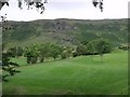
Campsie-Lennoxtown golf course
A course that enjoys a pretty spectacular backdrop.
Image: © Robert Murray
Taken: 1 Aug 2010
0.09 miles
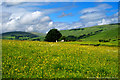
4
![Lennoxtown, Crow Road [2]](https://s2.geograph.org.uk/geophotos/02/59/29/2592926_22b0a221_120x120.jpg)
Lennoxtown, Crow Road [2]
At Balgrochan.
Image: © Robert Murray
Taken: 5 Sep 2011
0.10 miles
5
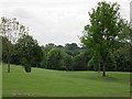
Campsie Golf Club
A newish looking course above Lennoxtown.
Image: © Richard Webb
Taken: 1 Jun 2012
0.12 miles
6
Lennoxtown Farm Ruin
An old farm building ruin located just west of Lennoxtown. The view shows Campsie Glen to the right of the tree and Fin Glen to the left.
Image: © Ron Shephard
Taken: 10 Jun 2014
0.23 miles