IMAGES TAKEN NEAR TO
Redhills View, GLASGOW, G66 7BL
Introduction
This page details the photographs taken nearby to Redhills View, G66 7BL by members of the Geograph project.
The Geograph project started in 2005 with the aim of publishing, organising and preserving representative images for every square kilometre of Great Britain, Ireland and the Isle of Man.

There are currently over 7.5m images from over14,400 individuals and you can help contribute to the project by visiting https://www.geograph.org.uk
Image Map
Images are licensed for reuse under creativecommons.org/licenses/by-sa/2.0
Notes
- Clicking on the map will re-center to the selected point.
- The higher the marker number, the further away the image location is from the centre of the postcode.
Image Listing (26 Images Found)
Images are licensed for reuse under creativecommons.org/licenses/by-sa/2.0
Image
Details
Distance
1
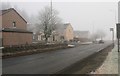
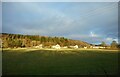
Houses at the edge of Lennoxtown
Beside the A891 on a frosty and foggy day.
Image: © Richard Sutcliffe
Taken: 1 Dec 2019
0.10 miles
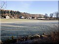
2
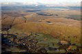
Lennoxtown from the air
Nestling at the foot of the Campsie Fells.
Image: © Thomas Nugent
Taken: 11 Dec 2017
0.12 miles
4
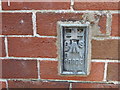
Ordnance Survey Flush Bracket S8925
This can be found on the wall of a private dwelling at Rowantree Place, Lennoxtown. The benchmark height is recorded as being 61.605 metres above sea level. For more detail see : http://www.bench-marks.org.uk/bm21297
Image: © Peter Wood
Taken: 5 Oct 2017
0.12 miles
5
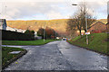
Houses beside the A891
Seen from the Strathkelvin Railway Path.
Image: © Richard Sutcliffe
Taken: 28 Jan 2023
0.13 miles
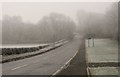
7
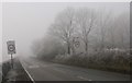
Entering Lennoxtown
The A891 on a frosty and foggy day.
Image: © Richard Sutcliffe
Taken: 1 Dec 2019
0.18 miles
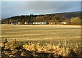
8
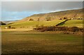
Fields east of Lennoxtown
The A891 runs across the centre of the photograph. The Campsie Fells dominate the background.
Image: © Richard Sutcliffe
Taken: 28 Jan 2023
0.18 miles
9
Campsie Road
Looking along the B822 from its junction with the A891 on a frosty foggy day.
Image: © Richard Sutcliffe
Taken: 1 Dec 2019
0.19 miles
10
The Field of Blood
The field between the A891 and the old railway line is called the Field of Blood.
This is apparently where MacGregor cattle thieves were massacred by local farmers in the early 1800s. See
https://www.trailsandtales.org/trails/heritage/field-of-blood.
Image: © Richard Sutcliffe
Taken: 28 Jan 2023
0.20 miles