IMAGES TAKEN NEAR TO
Auld Aisle View, GLASGOW, G66 3JT
Introduction
This page details the photographs taken nearby to Auld Aisle View, G66 3JT by members of the Geograph project.
The Geograph project started in 2005 with the aim of publishing, organising and preserving representative images for every square kilometre of Great Britain, Ireland and the Isle of Man.

There are currently over 7.5m images from over14,400 individuals and you can help contribute to the project by visiting https://www.geograph.org.uk
Image Map
Images are licensed for reuse under creativecommons.org/licenses/by-sa/2.0
Notes
- Clicking on the map will re-center to the selected point.
- The higher the marker number, the further away the image location is from the centre of the postcode.
Image Listing (19 Images Found)
Images are licensed for reuse under creativecommons.org/licenses/by-sa/2.0
Image
Details
Distance
1
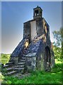
Kirkintilloch: Auld Aisle graveyard gateway and watchhouse
This 18th century gateway to the Auld Aisle graveyard is surmounted by a watchhouse and a belfry. The watchhouse, reached by steps built into the arch of the gateway, was intended to provide shelter to people guarding newly buried people against grave robbers. In the early 19th century there was a great shortage of corpses for anatomists and grave robbers, or resurrection men as they were called, made a living by stealing the newly dead and buried. The bell in the belfry may have been used to call for assistance or it may have housed the deid or mort bell which was tolled at funerals.
Image: © Martyn Gorman
Taken: 31 May 2009
0.11 miles
2
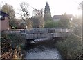
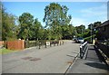
Kirkintilloch, Bridgeway Road
Crossing the Bothlin burn in Oxgang.
Image: © Robert Murray
Taken: 8 Nov 2009
0.14 miles
3
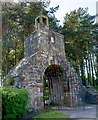
Kirkintilloch: entrance to the Auld Aisle graveyard
This 18th century gateway to the Auld Aisle graveyard is surmounted by a watchhouse and a belfry. The watchhouse, reached by steps built into the arch of the gateway, was intended to provide shelter to people guarding newly buried people against grave robbers. In the early 19th century there was a great shortage of corpses for anatomists and grave robbers, or resurrection men as they were called, made a living by stealing the newly dead and buried. The bell in the belfry may have been used to call for assistance or it may have housed the deid or mort bell which was tolled at funerals.
Image: © Martyn Gorman
Taken: 31 May 2009
0.16 miles
4
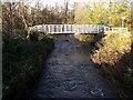
Kirkintilloch, bridge over Bothlin Burn
At Bridgeway Road Oxgang. The footbridge is part of a riverside walkway along side the Luggie Water.
Image: © Robert Murray
Taken: 8 Nov 2009
0.18 miles
5
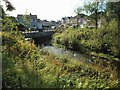
Bridgeway Road
The bridge crosses the Bothlin Burn.
Image: © Richard Sutcliffe
Taken: 18 Sep 2020
0.20 miles
6
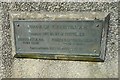
Bridge plaque
On the side of the bridge on Bridgeway Road crossing the Bothlin Burn Image
Image: © Richard Sutcliffe
Taken: 18 Sep 2020
0.20 miles
7
Bridge over the Bothlin Burn
The bridge carries Bridgeway Road over the burn.
Image: © Richard Sutcliffe
Taken: 18 Sep 2020
0.20 miles
8
Kirkintilloch, meeting of the waters
The confluence of the Luggie Water and the Bothlin Burn at Oxgang. In the spate conditions seen here each stream can easily be classified as rivers.
Image: © Robert Murray
Taken: 8 Nov 2009
0.21 miles
9
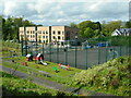
Flats, netball courts and play area
Looking down from Menzies Drive towards a block of flats on Stoneyetts Drive. There is a Spar shop in the corner ground floor, which houses Woodilee Post Office.
Image: © Richard Sutcliffe
Taken: 10 May 2022
0.21 miles
10
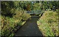
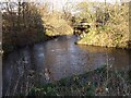
Footbridge over the Bothlin Burn
Just before the burn joins the Luggie Water.
Image: © Richard Sutcliffe
Taken: 18 Sep 2020
0.21 miles