IMAGES TAKEN NEAR TO
Eastergreens Avenue, GLASGOW, G66 3BH
Introduction
This page details the photographs taken nearby to Eastergreens Avenue, G66 3BH by members of the Geograph project.
The Geograph project started in 2005 with the aim of publishing, organising and preserving representative images for every square kilometre of Great Britain, Ireland and the Isle of Man.

There are currently over 7.5m images from over14,400 individuals and you can help contribute to the project by visiting https://www.geograph.org.uk
Image Map
Images are licensed for reuse under creativecommons.org/licenses/by-sa/2.0
Notes
- Clicking on the map will re-center to the selected point.
- The higher the marker number, the further away the image location is from the centre of the postcode.
Image Listing (117 Images Found)
Images are licensed for reuse under creativecommons.org/licenses/by-sa/2.0
Image
Details
Distance
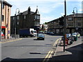
2
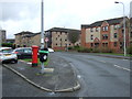
Donaldson Street, Kirkintilloch
Showing position of Postbox No. G66 160.
See Image] for postbox.
Image: © JThomas
Taken: 30 Mar 2017
0.06 miles
3
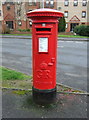
George V postbox on Donaldson Street, Kirkintilloch
Postbox No. G66 160.
See Image] for context.
Image: © JThomas
Taken: 30 Mar 2017
0.06 miles
4
Donaldson Street, Kirkintilloch
Looking west.
Image: © JThomas
Taken: 30 Mar 2017
0.06 miles
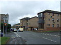
6
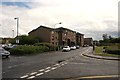
Flats on Southbank Drive, Kirkintilloch
Strathkelvin Place meets Southbank Drive in the foreground.
Image: © Richard Sutcliffe
Taken: 1 Jul 2016
0.08 miles
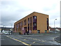
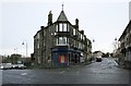
7
Dalrymple Court
Flats and shops at the junction of Townhead and Industry Street, Kirkintilloch.
Image: © Richard Sutcliffe
Taken: 22 Aug 2023
0.13 miles
8
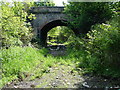
Back o' Loch Halt, Kirkintilloch
Picture taken from the trackbed, looking south to Lenzie, this was Kirkintilloch's rail connection to the outside world, and through the arch was one of Kirkintilloch's TWO railway stations, this halt - "Back o' Loch", and the main station for the town was 0.75km further north. The line left the main Glasgow to Edinburgh route just east of Lenzie station, and headed northwards to Kirkintilloch and the Campsie valley (Lennoxtown, Strathblane & Blanefield). A junction at Whitegates provided a spur to the Forth & Clyde canal for the shipment of coal at Middlemuir Basin (now infilled).
The bridge is scheduled for demolition as it is in the way of the new Kirkintilloch 'Link Road' which will use much of the railway's southern alignment to Lenzie and onwards to an extended M80 motorway at Muirhead.
Image: © Raymond Okonski
Taken: 15 May 2007
0.13 miles
9
Townhead, Kirkintilloch
This used to be a major junction in the town, with the main street continuing through the junction to Industry Street and onwards to Oxgang and Waterside. However the first phase of the town's link road (accessed by turning left) effectively emasculated Industry street by severing it a few hundred metres past this junction - and the Dalrymple Memorial can just be discerned in the sunlight (see other Geograph for a closer view). The road on the right leads south to Whitegates and Lenzie.
Image: © Raymond Okonski
Taken: 15 May 2007
0.13 miles
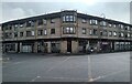
10
Road junction, Kirkintilloch
To the left is Waterside Road (the B757), which continues to the right as Townhead. Straight on is Industry Street.
Image: © Richard Sutcliffe
Taken: 10 Jan 2020
0.13 miles