IMAGES TAKEN NEAR TO
Tintock Village, GLASGOW, G66 2TA
Introduction
This page details the photographs taken nearby to Tintock Village, G66 2TA by members of the Geograph project.
The Geograph project started in 2005 with the aim of publishing, organising and preserving representative images for every square kilometre of Great Britain, Ireland and the Isle of Man.

There are currently over 7.5m images from over14,400 individuals and you can help contribute to the project by visiting https://www.geograph.org.uk
Image Map
Images are licensed for reuse under creativecommons.org/licenses/by-sa/2.0
Notes
- Clicking on the map will re-center to the selected point.
- The higher the marker number, the further away the image location is from the centre of the postcode.
Image Listing (13 Images Found)
Images are licensed for reuse under creativecommons.org/licenses/by-sa/2.0
Image
Details
Distance
1
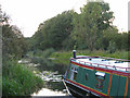
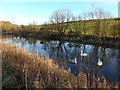
Forth & Clyde Canal at Tintock, near Kirkintilloch
A canal boat moored on a quiet stretch of the recently re-opened Forth & Clyde Canal - now again navigable from sea to sea
Image: © Brian D Osborne
Taken: 6 Sep 2005
0.01 miles
2

Forth and Clyde Canal
Just outside Kirkintilloch.
Image: © G Laird
Taken: 24 Jun 2012
0.07 miles
3
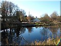
Tintock from across the Forth and Clyde Canal
Just east of Kirkintilloch.
Image: © Stephen Sweeney
Taken: 10 Nov 2010
0.09 miles
4
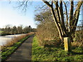
Marker stone by the Forth and Clyde Canal
A stone marked 'F.C.N.' (possibly standing for Forth and Clyde Navigation) pictured by the frozen canal.
Image: © Alan O'Dowd
Taken: 8 Dec 2022
0.16 miles
5
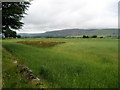
View of the Campsie Fells
A fine viewpoint of the Campsies from just above the towpath that follows the Forth and Clyde Canal at Harestanes, Kirkintilloch.
Image: © Chris Heaton
Taken: 11 Aug 2009
0.19 miles
7
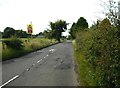
Double bend ahead
Heading west on the B8023.
Image: © Richard Sutcliffe
Taken: 31 Jul 2020
0.22 miles
8
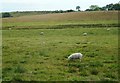
Grazing sheep
The Forth and Clyde Canal is just over the rise, where the trees are growing.
Image: © Richard Sutcliffe
Taken: 31 Jul 2020
0.22 miles
9
View towards Auchendavie Steadings
Auchendavie Steadings is built on the site of one of the forts on the line of the Antonine Wall. The ground around the building is part of the Scheduled Monument http://portal.historicenvironment.scot/designation/SM7050 covering the area of the fort.
The original farm steadings were converted into 7 individual properties in 2004.
Image: © Richard Sutcliffe
Taken: 31 Jul 2020
0.23 miles
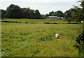
10
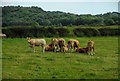
A small group of cattle
All but the one on the left were lying down, but as I got nearer they all started to get up.
Image: © Richard Sutcliffe
Taken: 31 Jul 2020
0.23 miles