IMAGES TAKEN NEAR TO
Waverley Park, GLASGOW, G66 2BL
Introduction
This page details the photographs taken nearby to Waverley Park, G66 2BL by members of the Geograph project.
The Geograph project started in 2005 with the aim of publishing, organising and preserving representative images for every square kilometre of Great Britain, Ireland and the Isle of Man.

There are currently over 7.5m images from over14,400 individuals and you can help contribute to the project by visiting https://www.geograph.org.uk
Image Map
Images are licensed for reuse under creativecommons.org/licenses/by-sa/2.0
Notes
- Clicking on the map will re-center to the selected point.
- The higher the marker number, the further away the image location is from the centre of the postcode.
Image Listing (93 Images Found)
Images are licensed for reuse under creativecommons.org/licenses/by-sa/2.0
Image
Details
Distance
1
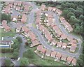
Waverley Park, Kirkintilloch
This housing development, completed in 2001 is built on the site that was originally Waverley Park Children's Home & Hospital. (1906 - 1993)
Image: © Kenneth Hall
Taken: Unknown
0.00 miles
2
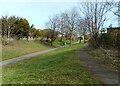
Footpath in Luggie Park
Leading to Waverley Park.
Image: © Richard Sutcliffe
Taken: 1 Apr 2022
0.07 miles
3
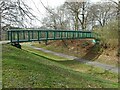
Bridge over a footpath
One footpath crosses another in Luggie Park. For a different view, see Image
Image: © Richard Sutcliffe
Taken: 1 Apr 2022
0.08 miles
4
Bridge over a footpath
One footpath crosses another in Luggie Park. For a different view, see Image
Image: © Richard Sutcliffe
Taken: 1 Apr 2022
0.08 miles
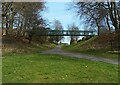
5
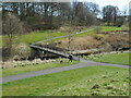
Bridge over the Luggie Water
Dog walkers were making good use of the network of paths beside the river.
Image: © Richard Sutcliffe
Taken: 1 Apr 2022
0.09 miles
6
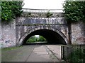
Luggie Water Aqueduct, Kirkintilloch
Quite an amazing structure adapted by Victorian railway engineers.
See RCAHMS report www.canmore.rcahms.gov.uk/en/site/168444/details/forth+and+clyde+canal+kirkintilloch+luggie+water+aqueduct/
Image: © Robert Murray
Taken: 29 May 2010
0.09 miles
7
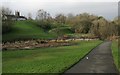
Path beside the Luggie Water
Looking towards one of the footbridges which crosses the river. In the distance is the tower of St Mary's Parish Church. On the left a large patch of Rhododendrons has recently been cleared.
Image: © Richard Sutcliffe
Taken: 15 Jan 2020
0.09 miles
8
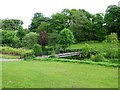
Footbridge over the Luggie, Kirkintilloch
The river flows through a parkland setting in a hollow on the eastern side of the town centre.
Image: © Robert Murray
Taken: 29 May 2010
0.09 miles
9
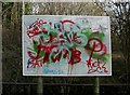
Graffitied sign
Seen beside the path in Image, this is a map of Kirkintilloch, but now impossible to read as such. No longer very useful, but quite colourful!
Image: © Richard Sutcliffe
Taken: 15 Jan 2020
0.09 miles
10
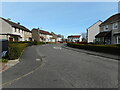
Waverley Crescent
A quiet residential street in Hillhead.
Image: © Richard Sutcliffe
Taken: 1 Apr 2022
0.10 miles