IMAGES TAKEN NEAR TO
Elm Bank, GLASGOW, G66 1PQ
Introduction
This page details the photographs taken nearby to Elm Bank, G66 1PQ by members of the Geograph project.
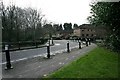
The Geograph project started in 2005 with the aim of publishing, organising and preserving representative images for every square kilometre of Great Britain, Ireland and the Isle of Man.

There are currently over 7.5m images from over14,400 individuals and you can help contribute to the project by visiting https://www.geograph.org.uk
Image Map
Images are licensed for reuse under creativecommons.org/licenses/by-sa/2.0
Notes
- Clicking on the map will re-center to the selected point.
- The higher the marker number, the further away the image location is from the centre of the postcode.
Image Listing (350 Images Found)
Images are licensed for reuse under creativecommons.org/licenses/by-sa/2.0
Image
Details
Distance
1

Traffic lights
Looking southeast from the junction of the A806, New Lairdlands Road and Catherine Street.
Image: © Richard Sutcliffe
Taken: 25 Apr 2022
0.04 miles
2
Turret Medical Centre
Seen from Catherine Street. Access to the centre is from David Donnelly Place.
Image: © Richard Sutcliffe
Taken: 25 Apr 2022
0.05 miles
3
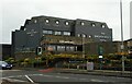
The Broadcroft Hotel
For many years this was Smith's Hotel. It has recently (2020/2021) had a make-over.
Image: © Richard Sutcliffe
Taken: 25 Apr 2022
0.07 miles
4
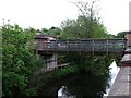
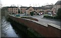
Footbridge over the Luggie, Kirkintilloch
Situated in a built up area east of the town centre.
Image: © Robert Murray
Taken: 29 May 2010
0.07 miles
5
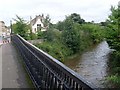
Luggie Water
From the bridge on Eastside.
Image: © Stephen Sweeney
Taken: 4 Sep 2009
0.07 miles
6
Houses beside the Luggie Water
These recently built houses are on the site of the former Lion Foundry, which operated here from 1880 until 1884. See Canmore https://canmore.org.uk/site/216122/kirkintilloch-eastside-lion-foundry to see images of the foundry when still operational.
Image: © Richard Sutcliffe
Taken: 15 Jan 2020
0.07 miles
7
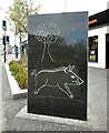
Gateway Marker, Catherine Street
This artwork on Catherine Street is by Marion Smith https://www.marionsmithsculptor.co.uk/commissions/cowgate-gateway-markers/. The boar and tree are similar to images found on a Roman distance slab found at Eastermains, Kirkintilloch, now in the Hunterian Museum, Glasgow http://collections.gla.ac.uk/#/details/ecatalogue/106713. The boar is a symbol of the Twentieth Legion, who constructed part of the Antonine Wall, which ran through what is now Kirkintilloch.
Image: © Richard Sutcliffe
Taken: 25 Apr 2022
0.08 miles
8
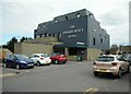
The Broadcroft Hotel
For many years this was Smith's Hotel. It has recently (2020/2021) had a make-over. It sits on the site of what was once Broadcroft House.
Image: © Richard Sutcliffe
Taken: 16 Nov 2022
0.08 miles
9
The Broadcroft Hotel
For many years this was Smith's Hotel. It has recently (2020/2021) had a make-over.
Image: © Richard Sutcliffe
Taken: 25 Apr 2022
0.08 miles
10
Lots of bollards
On the corner of Peter D. Stirling Road, Kirkintilloch, where it crosses the Luggie Water.
Image: © Richard Sutcliffe
Taken: 15 Jan 2020
0.08 miles