IMAGES TAKEN NEAR TO
High Street, GLASGOW, G66 1PN
Introduction
This page details the photographs taken nearby to High Street, G66 1PN by members of the Geograph project.
The Geograph project started in 2005 with the aim of publishing, organising and preserving representative images for every square kilometre of Great Britain, Ireland and the Isle of Man.

There are currently over 7.5m images from over14,400 individuals and you can help contribute to the project by visiting https://www.geograph.org.uk
Image Map
Images are licensed for reuse under creativecommons.org/licenses/by-sa/2.0
Notes
- Clicking on the map will re-center to the selected point.
- The higher the marker number, the further away the image location is from the centre of the postcode.
Image Listing (275 Images Found)
Images are licensed for reuse under creativecommons.org/licenses/by-sa/2.0
Image
Details
Distance
1
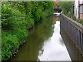
Luggie Water
Looking towards the Kilsyth Road bridge, just before its confluence with the River Kelvin.
Image: © Richard Sutcliffe
Taken: 15 Jan 2020
0.02 miles
2
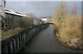
Kirikintilloch, Luggie Water
Canal like appearance on this stretch in the centre of Kirkie. The high deep piled bank is the answer to a history of flooding.
Image: © Robert Murray
Taken: 11 May 2011
0.03 miles
3
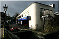
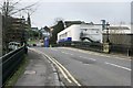
Kwik Fit, Kirkintilloch
On High Street, Kirkintilloch.
Image: © Richard Sutcliffe
Taken: 15 Jan 2020
0.04 miles
4
Luggie Water
The Luggie Bridge carries Eastside across the Luggie Water.
Image: © Richard Sutcliffe
Taken: 16 Nov 2022
0.04 miles
5
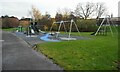
Kids Playzone, Kirkintilloch
Play park between Eastside and Glasgow Road. Deserted on a cold, mid-week afternoon.
Image: © Richard Sutcliffe
Taken: 16 Nov 2022
0.04 miles
6

Road Bridge over the Luggie Water
Shortly before the Luggie Water flows into the River Kelvin.
Image: © G Laird
Taken: 24 Jun 2012
0.05 miles
7
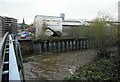
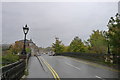
Luggie Bridge, Kirkintilloch
A Category B listed bridge http://portal.historicenvironment.scot/designation/LB36654 dating from 1715, but later widened. It carries High Street over the Luggie Water.
Image: © Richard Sutcliffe
Taken: 15 Jan 2020
0.05 miles
8
Luggie Bridge, Kirkintilloch
Eastside crossing Luggie Water
Image: © Tim Heaton
Taken: 9 Oct 2018
0.05 miles
9
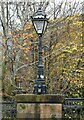
Lamp on Luggie Bridge
One of four similar lamps at the four corners of the bridge which carries Eastside over the Luggie Water. The bridge incorporates a stone bridge believed to date from 1715, with a more modern and wider structure on top. The bridge is Category B listed http://portal.historicenvironment.scot/designation/LB36654.
Image: © Richard Sutcliffe
Taken: 16 Nov 2022
0.06 miles
10
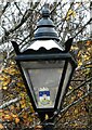
Lamp on Luggie Bridge
One of four similar lamps at the four corners of the bridge which carries Eastside over the Luggie Water Image The lamps all feature the Kirkintilloch coat of arms https://www.edlc.co.uk/heritage-arts/local-history/towns-and-villages/kirkintilloch-coat-arms.
Image: © Richard Sutcliffe
Taken: 16 Nov 2022
0.06 miles