IMAGES TAKEN NEAR TO
Glen Shirva Road, GLASGOW, G65 9QL
Introduction
This page details the photographs taken nearby to Glen Shirva Road, G65 9QL by members of the Geograph project.
The Geograph project started in 2005 with the aim of publishing, organising and preserving representative images for every square kilometre of Great Britain, Ireland and the Isle of Man.

There are currently over 7.5m images from over14,400 individuals and you can help contribute to the project by visiting https://www.geograph.org.uk
Image Map
Images are licensed for reuse under creativecommons.org/licenses/by-sa/2.0
Notes
- Clicking on the map will re-center to the selected point.
- The higher the marker number, the further away the image location is from the centre of the postcode.
Image Listing (50 Images Found)
Images are licensed for reuse under creativecommons.org/licenses/by-sa/2.0
Image
Details
Distance
1
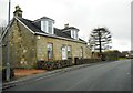
Cottage on Glenshirva Road, Twechar
Overlooking the Forth and Clyde Canal.
Image: © Richard Sutcliffe
Taken: 9 Mar 2020
0.01 miles
2
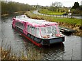
Antonine approaching Twechar Bridge
A sightseeing boat based further down the canal at the Falkirk Wheel.
Image: © Richard Sutcliffe
Taken: 9 Mar 2020
0.02 miles
3
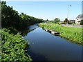
Forth and Clyde Canal
Forth and Clyde Canal at Twechar.
Image: © Philip Halling
Taken: 28 Jun 2019
0.03 miles
4
Forth and Clyde Canal from Twechar Bridge
Looking west down the canal, which runs parallel with the B8023 at this point.
Image: © Chris Heaton
Taken: 11 Aug 2009
0.03 miles
5
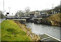
Twechar Bridge
In the background is the lifting bridge carrying Main Street over the Forth and Clyde Canal. The bridge was built in 1960 and replaced the original bascule Bridge a few metres to the south. The original supports for the bascule bridge are still evident.
Image: © Richard Sutcliffe
Taken: 9 Mar 2020
0.03 miles
6
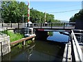
Canal bridge at Twechar
Road bridge crossing the Forth and Clyde canal at Twechar.
Image: © Philip Halling
Taken: 28 Jun 2019
0.03 miles
7
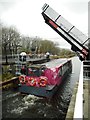
Canal bridge raised for Antonine
Antonine is a sightseeing boat based further down the canal at the Falkirk Wheel.
The bridge at Twechar was built in 1960 and replaced the original bascule Bridge (since removed) a few metres to the south (from where this photograph was taken). It only has a clearance of 1.25m when closed, so boats wishing to pass through must request the opening of the bridge.
Image: © Richard Sutcliffe
Taken: 9 Mar 2020
0.04 miles
8
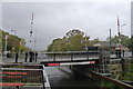
Closed bridge at Twechar
Safety concerns over this (and another) bridge on the Forth and Clyde Canal have led to them being closed for some time https://www.scottishcanals.co.uk/news/bridge-restrictions-operational-changes/
The Inland Waterways Association "has told Scottish Canals that the current indefinite closure of the Forth & Clyde Canal is unacceptable. This follows the claim by Scottish Canals that it does not have the funds necessary to repair two lift bridges … The two lift bridges, at Twechar and Bonnybridge, are situated around the middle of the Scottish lowlands canal, and their closure would affect all local traffic, the hire boat trade and any seagoing craft wishing to traverse the canal from one coast to the other." https://www.waterways.org.uk/news/view?id=346
This must explain why, on a 17 mile walk along the canal over a period of three days I didn't see any craft moving along the canal. The towpath, on the other hand, was well used by cyclists.
Image: © Tim Heaton
Taken: 9 Oct 2018
0.04 miles
9
Distance marker at Twechar Bridge
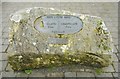
Damaged cast iron plaque beside the canal towpath
FORTH & CLYDE CANAL
KILSYTH | KIRKINTILLOCH
3½KM | 5½KM
TWECHAR
STRATHCLYDE
EUROPEAN
PARTNERSHIP
Image: © Richard Sutcliffe
Taken: 9 Mar 2020
0.04 miles
10
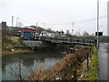
Twechar Bridge over the Forth and Clyde Canal
Quoting from the guide to the Millennium Link "Here, a single-leaf bascule bridge has been refurbished and was recommissioned in January 2001. The work involved replacing the mechanical and electrical operating equipment, replacing the bridge structure and reinstating the control system. The control building has been rebuilt and the area around the bridge site landscaped."
Image: © Gordon Brown
Taken: 28 Jan 2012
0.04 miles