IMAGES TAKEN NEAR TO
Neilston Walk, GLASGOW, G65 9PL
Introduction
This page details the photographs taken nearby to Neilston Walk, G65 9PL by members of the Geograph project.
The Geograph project started in 2005 with the aim of publishing, organising and preserving representative images for every square kilometre of Great Britain, Ireland and the Isle of Man.

There are currently over 7.5m images from over14,400 individuals and you can help contribute to the project by visiting https://www.geograph.org.uk
Image Map
Images are licensed for reuse under creativecommons.org/licenses/by-sa/2.0
Notes
- Clicking on the map will re-center to the selected point.
- The higher the marker number, the further away the image location is from the centre of the postcode.
Image Listing (55 Images Found)
Images are licensed for reuse under creativecommons.org/licenses/by-sa/2.0
Image
Details
Distance
1
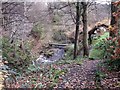
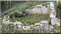
Kilsyth, bridge in the glen
Private footbridge over the Garrell Burn adjacent to the old blackening mill, now a private dwelling. Unseen in this photograph is the weir - for which see http://www.geograph.org.uk/photo/1792704
Image: © Robert Murray
Taken: 15 Nov 2009
0.09 miles
2
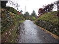
Allanfauld Road
Serves Allanfauld, a farm and some residential properties. It runs up the west side of the Garrell Burn gorge.
Image: © Richard Webb
Taken: 27 Jan 2012
0.10 miles
3
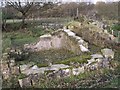
Kilsyth Castle (ruins)
Destroyed on the orders of one Mr. O. Cromwell, the Lord Protector of England and invader of Scotland that histories of the country seem to have forgotten .......
See RCAHMS record http://canmore.rcahms.gov.uk/en/site/45873/details/kilsyth+castle/
It is possible to view the castle remains, but they are in private grounds and visitors must first ask at the house to gain entry.
Image: © Robert Murray
Taken: 15 Nov 2009
0.10 miles
4
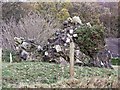
Kilsyth Castle, (ruins)
Toppled tower. See RCAHMS record http://canmore.rcahms.gov.uk/en/site/45873/details/kilsyth+castle/
It is possible to view the castle remains, but they are in private grounds and visitors must first ask at the house to gain entry.
Image: © Robert Murray
Taken: 15 Nov 2009
0.12 miles
5
Kilsyth Castle (ruin)
Part of the remains of what older maps call "Kilsyth Castle".
It is possible to view the castle remains, but they are in private grounds and visitors must first ask at the house to gain entry.
Image: © Texas Radio and The Big Beat
Taken: 15 Nov 2009
0.13 miles
6
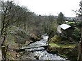
Looking down the glen
Featuring private bridge.
Image: © Robert Murray
Taken: 7 Apr 2010
0.14 miles
7
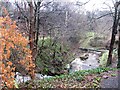
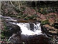
Garrell Burn
The burn falls off the Campsie escarpment over several waterfalls including this one hidden in a garden.
Image: © Richard Webb
Taken: 27 Jan 2012
0.14 miles
8
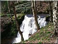
Waterfall on the Garrel
Probably not a natural waterfall. The First Ed. O.S. [Stirlingshire Sht. XXVIII.8. www.nls.uk/maps/os/25inch/view/?sid=74983722] surveyed in 1859 shows a sluice in the same position as the one visible in this photo with the lade running into a chemical works.
Man made or natural it is quite spectacular in a good head of water.
Image: © Robert Murray
Taken: 7 Apr 2010
0.14 miles
9
Kilsyth, up the Garrell Burn
Delightful waterfall in spate.
Image: © Robert Murray
Taken: 15 Nov 2009
0.15 miles
10
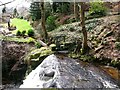
Garrel Sluice
A modern sluice to replace the original industrial one of the 19th. century. A decorative lade is used to create a water feature in landscaped gardens.
Image: © Robert Murray
Taken: 7 Apr 2010
0.15 miles