IMAGES TAKEN NEAR TO
Strone Gardens, GLASGOW, G65 9LR
Introduction
This page details the photographs taken nearby to Strone Gardens, G65 9LR by members of the Geograph project.
The Geograph project started in 2005 with the aim of publishing, organising and preserving representative images for every square kilometre of Great Britain, Ireland and the Isle of Man.

There are currently over 7.5m images from over14,400 individuals and you can help contribute to the project by visiting https://www.geograph.org.uk
Image Map
Images are licensed for reuse under creativecommons.org/licenses/by-sa/2.0
Notes
- Clicking on the map will re-center to the selected point.
- The higher the marker number, the further away the image location is from the centre of the postcode.
Image Listing (24 Images Found)
Images are licensed for reuse under creativecommons.org/licenses/by-sa/2.0
Image
Details
Distance
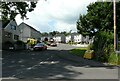
1
The edge of Kilsyth
The buildings on the left are part of Queenzieburn Industrial Estate. The small loch is within Dumbreck Local Nature Reserve. The Kilsyth Hills are behind.
Image: © Richard Sutcliffe
Taken: 18 Sep 2020
0.07 miles
2
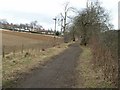
Looking towards Balmalloch
Looking East towards Balmalloch, Kilsyth along the bed of a light railway line converted into a path.
Image: © Jim Bain
Taken: 26 Feb 2006
0.12 miles
4
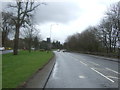
Glasgow Road (A803), Kilsyth
Looking north east.
Image: © JThomas
Taken: 30 Mar 2017
0.12 miles
5
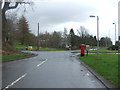
Glasgow Road, Kilsyth
Showing position of Postbox No. G65 937.
See Image] for postbox
Image: © JThomas
Taken: 30 Mar 2017
0.13 miles
6
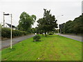
The former and currnet Glasgow Road (A803), Kilsyth
Looking north-eastward.
Image: © Peter Wood
Taken: 3 Sep 2022
0.14 miles
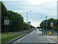
8
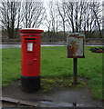
Elizabethan postbox, on Glasgow Road, Kilsyth
Postbox No. G65 937.
See Image] for context.
Image: © JThomas
Taken: 30 Mar 2017
0.15 miles
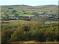
9
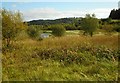
Dumbreck Marsh Local Nature Reserve
In the past this was an area of coke and coal waste with mineral railways lines. Today the site includes ponds and large areas of grassland, supporting grassland and wetland birds and other species.
Image: © Richard Sutcliffe
Taken: 9 Sep 2020
0.15 miles