IMAGES TAKEN NEAR TO
Hill Road, GLASGOW, G65 0RQ
Introduction
This page details the photographs taken nearby to Hill Road, G65 0RQ by members of the Geograph project.
The Geograph project started in 2005 with the aim of publishing, organising and preserving representative images for every square kilometre of Great Britain, Ireland and the Isle of Man.

There are currently over 7.5m images from over14,400 individuals and you can help contribute to the project by visiting https://www.geograph.org.uk
Image Map
Images are licensed for reuse under creativecommons.org/licenses/by-sa/2.0
Notes
- Clicking on the map will re-center to the selected point.
- The higher the marker number, the further away the image location is from the centre of the postcode.
Image Listing (51 Images Found)
Images are licensed for reuse under creativecommons.org/licenses/by-sa/2.0
Image
Details
Distance
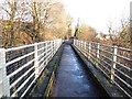
1
Viaduct across the Garrel Glen
Formerly a mineral railway line.
Image: © Robert Murray
Taken: 7 Apr 2010
0.03 miles
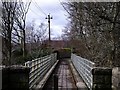
2
Viaduct, High Line
A former railway viaduct over the Garrell Burn gorge. The railway was a mineral line: Bairds of Gartshore's Railway, which served coal and ironstone mines around Kilsyth. Now this part of the trackbed is the Neilston Walk a very level path.
Image: © Richard Webb
Taken: 27 Jan 2012
0.04 miles
3
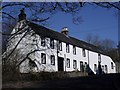
Old corn mill, Kilsyth
The Garrel mill on the Tak-Ma-Doon Road. This building is spread across two squares, the nearest part being in the same as the photographer.
Image: © Robert Murray
Taken: 22 Feb 2010
0.04 miles
4
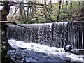
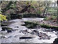
Kilsyth, Garrel weir
The weir traps the water that fed the lade to the mills and continues to supply the water for the canal feeder to Townhead Reservoir/Banton Loch. See also http://www.geograph.org.uk/photo/1582500
Image: © Robert Murray
Taken: 15 Nov 2009
0.06 miles
5
Kilsyth, Garrel sluice and weir
The sluice which allowed water from the burn to power the Garrel Corn Mill on the Tak Me Doon Road and still functions in the supply of water to the canal feeder to Townhead Reservoir. See also http://www.geograph.org.uk/photo/1582518
Image: © Robert Murray
Taken: 15 Nov 2009
0.06 miles
6
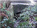
Kilsyth, old mill race
Now used solely as a canal feeder to the Forth & Clyde Canal. This is the water going under the Tak-Me-Doon road up the brae from Kilsyth town. To the left on this photo is where the mill water wheel would have been situated.
Image: © Robert Murray
Taken: 23 Nov 2009
0.06 miles
7
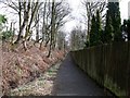
Lane from Hill Road to the Tak-Ma-Doon
Formerly a mineral railway line to the Neilston Pit.
Image: © Robert Murray
Taken: 7 Apr 2010
0.06 miles
8
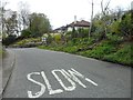
NE edge of Kilsyth
Entering the town on Tak-ma-doon Road.
Image: © Stephen Sweeney
Taken: 28 Apr 2012
0.06 miles
9
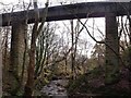
Kilsyth, Viaduct over Garrel Glen
A single track railway viaduct that once carried the mineral line connecting the Neilston pits and the Forth & Clyde Canal at Twechar it is now utilised as part of the north Kilsyth path network.
Image: © Robert Murray
Taken: 15 Nov 2009
0.06 miles
10
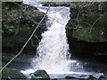
Kilsyth, the lowest spout
The lowest on the Garrel just before it enters the town of Kilsyth. See also http://www.geograph.org.uk/photo/1593784 and http://www.geograph.org.uk/photo/1583026
Image: © Robert Murray
Taken: 23 Nov 2009
0.07 miles