IMAGES TAKEN NEAR TO
Banton, Kilsyth, GLASGOW, G65 0QZ
Introduction
This page details the photographs taken nearby to G65 0QZ by members of the Geograph project.
The Geograph project started in 2005 with the aim of publishing, organising and preserving representative images for every square kilometre of Great Britain, Ireland and the Isle of Man.

There are currently over 7.5m images from over14,400 individuals and you can help contribute to the project by visiting https://www.geograph.org.uk
Image Map
Images are licensed for reuse under creativecommons.org/licenses/by-sa/2.0
Notes
- Clicking on the map will re-center to the selected point.
- The higher the marker number, the further away the image location is from the centre of the postcode.
Image Listing (45 Images Found)
Images are licensed for reuse under creativecommons.org/licenses/by-sa/2.0
Image
Details
Distance
1
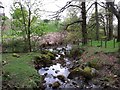
Banton, meeting of the waters
The Banton Burn flowing from the left (east) joins with the Drum Burn from the foreground (north).
Image: © Robert Murray
Taken: 8 May 2010
0.09 miles
2
Meeting of the waters, Banton
This wee village certainly is a busy place for burns.
Here we see the Banton Burn on the left being joined by - a hard to see - Craigdouffie Burn on the right - which at this point flows through private property.
Image: © Robert Murray
Taken: 8 May 2010
0.09 miles
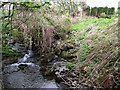
3

The Shawend Burn near Banton
Flowing down the glen alongside the road from Upper Banton. Locals might call this burn something else.
Image: © Robert Murray
Taken: 30 Jan 2010
0.10 miles
4
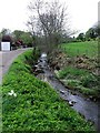
The Banton Burn on the edge of Banton
The burn winds its way along the northern outskirts of the village from which it takes its name.
Image: © Robert Murray
Taken: 8 May 2010
0.11 miles
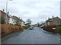
5
Banton
The road between Banton and High Banton.
Image: © Richard Webb
Taken: 21 Jun 2013
0.14 miles
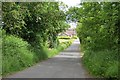
6

Road into Banton
This is at the foot of the brae from High Banton to Low Banton though the latter prefix isn't normally applied nowadays.
Image: © Robert Murray
Taken: 30 Jan 2010
0.14 miles
7
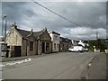
Banton, North Lanarkshire
A few houses in the village just north of the crossroads.
Image: © Stephen Sweeney
Taken: 4 Aug 2016
0.16 miles
10
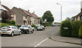
Mill Road, Banton
Seen from the junction with Valleybank.
Image: © Richard Sutcliffe
Taken: 18 Jun 2018
0.17 miles